An Overview of Clouds

When you look up at the clouds, it’s never quite the same twice. Sometimes you’ll see wispy streaks high above, other times a blanket of gray, and on stormy days, towering thunderclouds.

Meteorologists group these into families based on how high they form in the atmosphere.

By learning to recognise them, you can start to read the sky like a weather map and even predict what might be coming next.

This classification system helps meteorologists, and cloud lovers, identify and quickly use them to interpret current or upcoming weather conditions.
Types of Clouds

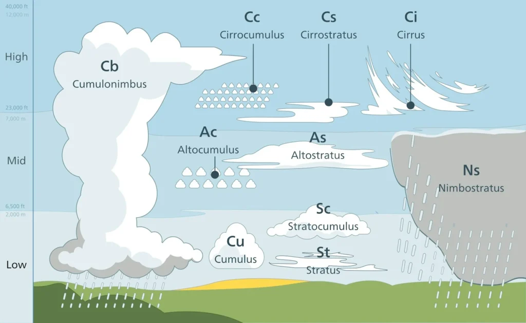
High-Level Clouds (20,000–40,000 ft)

Cirrus (Ci): Wispy, hair-like clouds made entirely of ice crystals. They often signal a change in the weather within a day or two.
Cirrostratus (Cs): Thin and sheet-like, they cover the sky in a veil. They can produce halos around the Sun or Moon.
Cirrocumulus (Cc): Small, rippling patches that look like fish scales — sometimes called a “mackerel sky.”

Mid-Level Clouds (6,500–20,000 ft)

Altostratus (As): Large, gray sheets that dim the Sun. They often thicken into nimbostratus clouds, bringing steady rain or snow.
Altocumulus (Ac): Puffy, cotton-like patches that may appear in groups. Their presence in the morning can sometimes hint at afternoon thunderstorms.

Low-Level Clouds (surface–6,500 ft)

Stratus (St): Flat, gray layers that blanket the sky. They often bring overcast conditions with drizzle or mist.
Stratocumulus (Sc): Lumpy, rolling clouds in a widespread layer. They are usually dry but may produce light drizzle.
Nimbostratus (Ns): Thick, dark clouds that cover the sky and bring prolonged rain or snow.

Vertical-Developing (rising across levels)

Cumulus (Cu): Fluffy, white “fair-weather” clouds shaped like cotton balls. They can grow taller if the atmosphere is unstable.

Cumulonimbus (Cb) Towering thunderstorm clouds with anvil-shaped tops. They produce heavy rain, lightning, hail, and sometimes tornadoes
Cloud Diagram

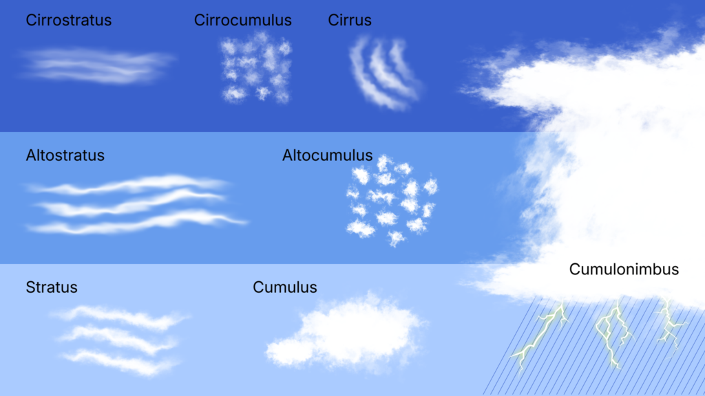
By recognizing these ten cloud types, we gain insight into how the atmosphere works and how weather develops.

From delicate cirrus clouds high above to powerful cumulonimbus storms stretching through all levels, clouds help us read the sky and prepare for the changes it may bring.

More useful info can be obtained from the UK Met Office

Tony S.
Tony is based in Australia and focuses on how false conspiracy theories spread and harm society, with an emphasis on clear facts and critical thinking.

Related

Contrails: A Brief History

Contrails have been observed since the earliest high-altitude flights of 1918. Once a wartime hazard, they became subjects of meteorological and climate research. This article traces their history, physics, and growth—from Schmidt and Appleman’s studies to today’s traffic-driven skies filled with human-made cirrus.

Mammatus Clouds

Mammatus clouds are pouch-like protrusions hanging beneath the anvil of cumulonimbus clouds or, more rarely, other cloud types. They mark areas of intense downdraft and are striking indicators of turbulent atmospheric processes.

Sun Dimming and SRM

Sun dimming, or solar radiation management (SRM), involves deliberately reducing incoming solar energy. A key method, stratospheric aerosol injection (SAI), disperses reflective particles to raise Earth’s albedo, similar to cooling observed after volcanic eruptions. While models suggest this could lower global temperatures, risks include ozone depletion, altered rainfall patterns, and termination shock make it a highly uncertain intervention.

Iridescent Contrails: I Can See the Chemicals Mixing

Incandescent contrails are a type of contrail that form not from engine exhaust, but from rapid pressure drops around an aircraft’s wings which cause water vapor in the atmosphere to condense and freeze. When lit by the sun, these wake contrails can appear unusually bright or glowing like a rainbow. Their origin is purely aerodynamic and optical: no chemicals are sprayed, and the effect arises from ice crystals interacting with sunlight.

Fractus Clouds

Fractus clouds are small, irregular fragments that break away from larger cloud masses. They often form beneath precipitating clouds or along gust fronts, moving rapidly and constantly changing shape.

What are Chemtrails

Chemtrails refers to a widely circulated conspiracy theory claiming that the white streaks left behind by high-altitude aircraft are actually chemicals deliberately sprayed into the atmosphere for purposes such as weather manipulation, population control, or geoengineering. There is no credible evidence supporting this claim.

Featured

Counting the Cost of a Nationwide Chemtrail Programme

What would it actually take to run a nationwide US “chemtrail” operation? Our analysis reveals the staggering logistics — 165 aircraft, thousands of workers, and billions of dollars each year. The numbers tell their own story.

Why Contrails Can Linger and Spread

Contrails can linger and spread because they are essentially man-made cirrus clouds formed from ice crystals at high altitude. A cloud is made of water vapour, just like a contrail. Therefore if a cloud can linger, so can a contrail. When an aircraft’s hot exhaust mixes with cold, humid air, the resulting condensation freezes, creating thin white trails.

The Logistics of Secrecy: The Impossible Scale of a Chemtrail Programme

This article examines the chemtrail conspiracy through physics, engineering, and economics. It shows that a nationwide spraying programme would require hundreds of aircraft, thousands of staff, and billions in funding—leaving clear evidence. The science of contrails fully explains the phenomenon without invoking any secret aerosol operation.

The chemtrail conspiracy would collapse within a few years

Physicist David Grimes’s 2016 mathematical model shows that large conspiracies such as Chemtrails inevitably unravel through leaks. His analysis demonstrates that a secret global spraying programme involving thousands of people over decades is statistically implausible.

Cloud Seeding: You can’t Just Make Rain

It is impossible to manufacture rain, which depends on water vapour in the atmosphere. This is supplied by heat and evaporation from the Earth’s surface. Only when moist air cools and condenses into clouds is there potential for rain. Techniques such as cloud seeding cannot create this water; they can only encourage raindrops to form in clouds that are already primed to produce rain.

Cloud Seeding is Not Chemtrails

Cloud seeding and so-called “chemtrails” are fundamentally different, though often confused in conspiracy circles. Cloud seeding is a small-scale, scientifically documented technique in which aircraft introduce minute amounts of silver iodide into existing clouds to encourage rainfall; it does not involve spraying chemicals into clear skies, nor does it leave visible white streaks. Chemtrails.

Popular Categories