
Hidden Ripples Shaping Our Clouds
Though they look striking, gravity waves are entirely natural and an important part of how the atmosphere balances and moves energy.
Atmospheric gravity waves are like the ripples that spread across a pond after a stone is dropped, except they move through air instead of water.
When air is pushed upward by mountains, storms, or weather fronts into a stable layer of the atmosphere, gravity pulls it back down.
This up-and-down motion sets off a wave that travels through the sky, carrying energy as it goes.
These waves can shape clouds into smooth bands or rippling patterns, and sometimes cause turbulence that aircraft experience when flying through them.
Fundamental Component of Meteorology
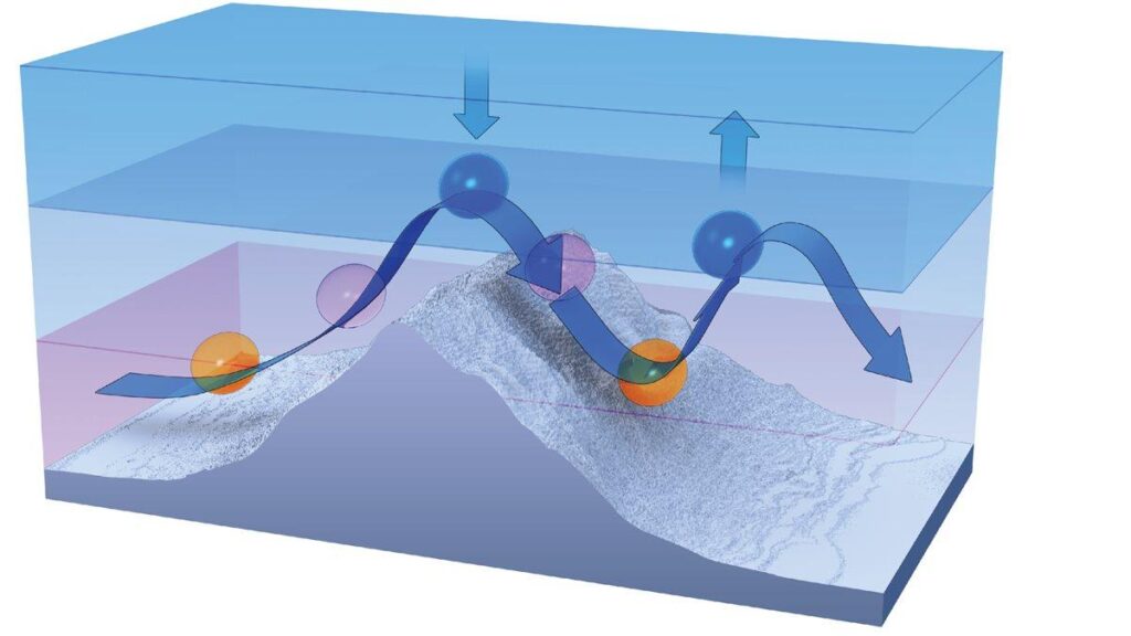
Gravity waves in the atmosphere are oscillations generated when air is displaced vertically in a stable layer and gravity acts as the restoring force.
They are a fundamental component of meteorology, responsible for the propagation of energy and momentum between different layers of the atmosphere.
While invisible in most cases, they often reveal themselves indirectly, through distinctive cloud patterns such as undulating bands, lenticular shapes, and rippled sheets.
Understanding gravity waves is essential to interpreting weather behaviour, cloud formation, and turbulence.
They occur at all scales, from small ripples a few hundred metres long to planetary-scale waves that influence jet streams and global circulation.
Their presence in the atmosphere demonstrates how stability, wind shear, and buoyancy interact in complex ways.
Misconceptions and Clarifications
Some misconceptions attribute the appearance of wave clouds or rippled sky patterns to artificial or electromagnetic sources. There is no physical mechanism by which electromagnetic radiation, including radio or microwave emissions, can induce the large-scale air displacements required for gravity wave formation.
Electromagnetic fields in the atmosphere are extremely weak compared with the mechanical forces governing air motion.
Gravity waves result from the interaction of buoyancy, stability, and wind flow, all of which operate on energy scales far exceeding any EM influence.
For example:
- The energy density of a typical atmospheric gravity wave is several orders of magnitude greater than the energy density of local radio signals.
- The ionospheric research transmissions used in facilities such as HAARP operate at altitudes tens of kilometres above the region where tropospheric clouds form.
- The wavelengths of radio waves are measured in metres, while atmospheric wave structures span kilometres. They occur in completely different physical regimes.
Numerous field studies, including lidar and radar measurements, confirm that observed wave clouds correspond to natural oscillations within stable layers.
There is no scientific evidence linking them to electromagnetic or human-made sources.
Gravity Waves Interaction with Clouds
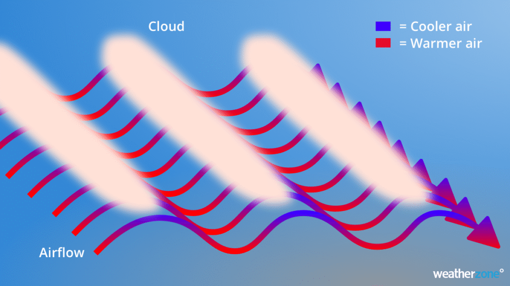
Clouds are among the most visible manifestations of gravity waves. The interaction between a propagating wave and a moist layer produces alternating zones of condensation and evaporation.
This process outlines the wave structure in the sky.
When air in the rising phase of a gravity wave cools to its dew point, moisture condenses to form cloud. When it descends, it warms adiabatically, and the cloud dissipates.
The repeating cycle produces bands, ripples, or lens-like formations, depending on the geometry of the wave and the moisture distribution.
These wave clouds are valuable to meteorologists because they reveal the location and wavelength of the underlying oscillations.
They often form in areas of strong stability, such as beneath temperature inversions or above mountain ranges.
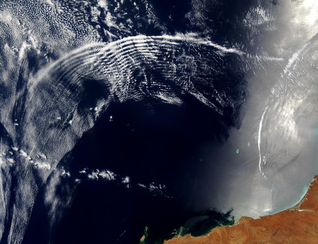
Satellite observations show gravity-wave patterns as evenly spaced lines of cloud and clear air, sometimes extending for hundreds of kilometres.
Types of Clouds Formed by Gravity Waves
1. Lenticular Clouds (Lenticularis)
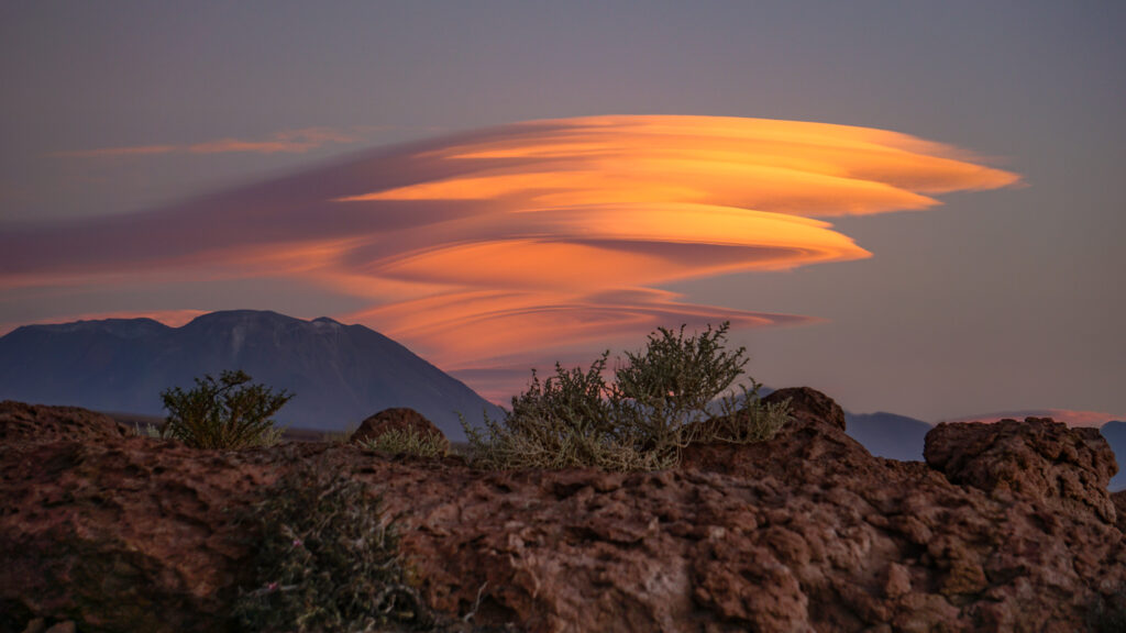
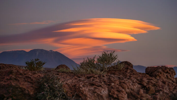
Perhaps the most distinctive gravity wave clouds are lenticular clouds, which form when stable air flows over mountains. As the air ascends on the windward side, it cools and condenses into a stationary, lens-shaped cloud at the crest of the wave.
On the leeward side, descending air evaporates the cloud. This pattern repeats with successive oscillations, forming multiple stacked layers that remain nearly motionless despite strong winds aloft.
Lenticular clouds are a direct indication of mountain wave activity. Their smooth, sculpted appearance and stationary behaviour distinguish them from convective or turbulent clouds. Pilots use lenticulars as markers for potential wave lift and turbulence.
2. Undulatus Clouds
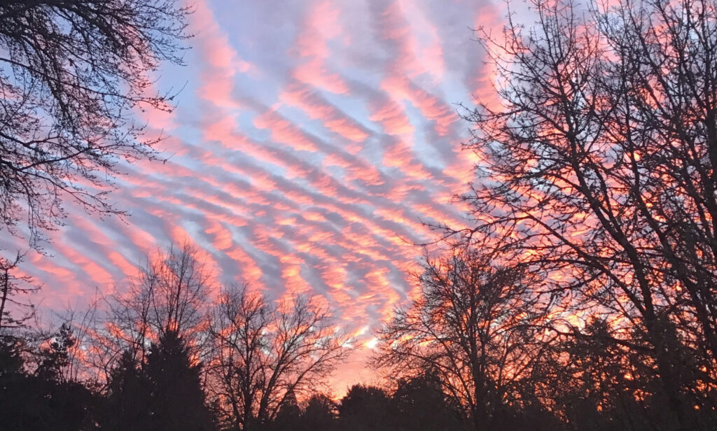
Undulatus formations, as previously discussed, result from broad, horizontally propagating gravity waves in stable layers of the troposphere.
They can occur in several cloud genera such as Altocumulus, Stratocumulus, and Cirrocumulus, and display parallel or wavy bands.
These patterns represent the crests and troughs of atmospheric waves, often generated by wind shear, frontal boundaries, or orographic effects.
The spacing and alignment of the waves correspond to the wavelength and propagation direction of the gravity waves. Observing undulatus formations provides insight into upper-air stability and wind flow.
3. Fluctus (Kelvin–Helmholtz) Clouds
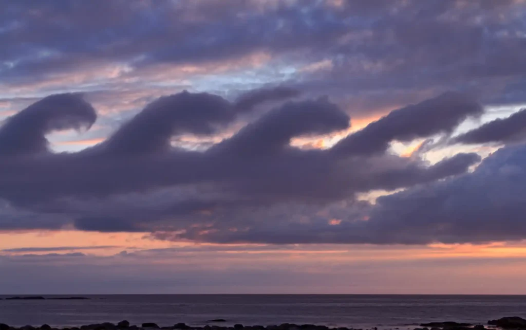
In cases where vertical wind shear is strong, gravity waves may evolve into Kelvin–Helmholtz waves, which appear as a series of evenly spaced curls resembling ocean breakers.
They form when the upper and lower air layers move at different speeds, producing a shearing instability that causes the wave crests to overturn. These structures are short-lived but illustrate the transition between stable wave motion and turbulent mixing.
Kelvin–Helmholtz clouds indicate the upper limit of gravity wave amplitude before instability and breakdown occur. They can appear in Cirrus, Altostratus, or Stratocumulus layers and signify the onset of turbulence.
4. Mountain Wave Clouds
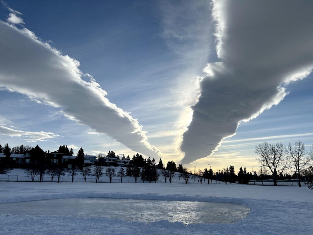
Orographic gravity waves can also produce wave trains extending downwind of mountains. These often appear as repeating bands of Altocumulus or Lenticular clouds, aligned parallel to the mountain range.
The phenomenon is common in areas such as the Southern Alps of New Zealand or the Rocky Mountains in North America, where strong prevailing winds encounter high terrain.
In cross-section, these waves produce alternating regions of lift and subsidence. Aircraft flying through these zones can experience alternating updrafts and downdrafts, sometimes exceeding several metres per second.
5. Roll Clouds
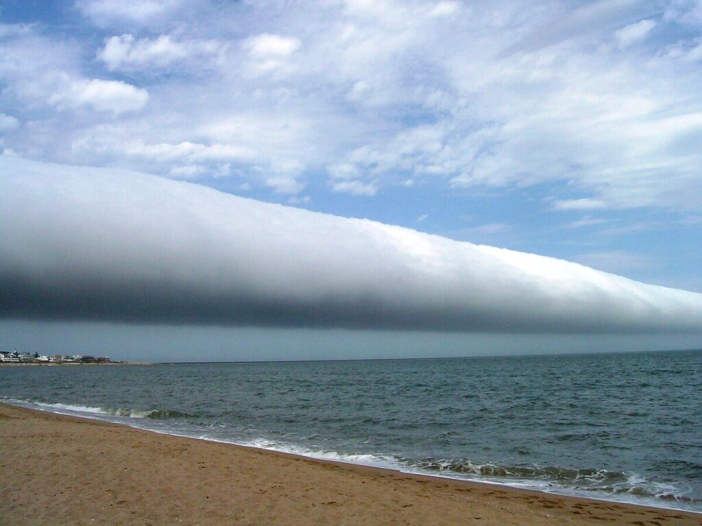
Roll clouds, while often associated with cold fronts, can also form in response to low-level gravity waves generated by density currents or sea breezes.
These elongated, horizontal tubes of rotating air represent a single crest of a travelling gravity wave. The rotation is maintained by the balance between buoyancy and the horizontal pressure gradient.
Formation Mechanics
Gravity waves form when a stable layer of air is disturbed. Atmospheric stability refers to the tendency of an air parcel to resist vertical displacement.
In a stable environment, a parcel lifted upward becomes cooler and denser than its surroundings, so gravity pulls it back down.
The downward motion can overshoot the equilibrium point, causing the parcel to oscillate. This repeating movement establishes a gravity wave.
These waves are distinct from gravitational waves in astrophysics; they are a fluid-dynamic phenomenon, not a space-time distortion.
The name “gravity wave” refers to the role of gravity as the restoring force acting on a displaced mass of air.
Common sources of gravity waves include:
- Orographic lifting, where wind flows over mountains or ridges.
- Frontal systems, where air masses of different densities interact.
- Convective outflows, where rising warm air or downdrafts generate wave disturbances.
- Jet stream shear, which can initiate oscillations at boundaries between air layers moving at different speeds.
- Thunderstorms, where powerful updrafts produce ripples that propagate away from the convective core.
Once generated, the waves propagate vertically or horizontally, depending on wind structure and stability. When they encounter layers with sufficient moisture, they become visible as cloud formations.
Wave Propagation and Dynamics
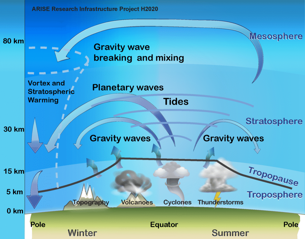
In a stratified atmosphere, gravity waves propagate through regions of alternating upward and downward motion.
Their properties are governed by the Brunt–Väisälä frequency (N), which defines the natural frequency of oscillation for a displaced parcel in a stable environment.
This frequency is determined by the vertical temperature gradient and the acceleration due to gravity.
If the frequency of a disturbance matches or is lower than this natural frequency, the wave can propagate; if it exceeds it, the motion is damped.
This explains why gravity waves are sustained only within layers of stable stratification and not within turbulent or convectively unstable air.
Each wave consists of alternating regions of ascent and descent:
- In the crests, air rises, cools, and may condense into cloud if the humidity is near saturation.
- In the troughs, air descends, warms, and evaporates any existing cloud.
This alternating process creates patterns of cloud and clear sky that can be directly observed from the ground or satellite imagery.
The wavelength of a gravity wave (the distance between successive crests) depends on the speed of the wind and the strength of the stratification.
Shorter wavelengths are associated with small-scale ripples such as those forming undulatus or lacunosus patterns, while long wavelengths produce extensive bands of altostratus or cirrostratus clouds extending for hundreds of kilometres.
Energy Transfer and Atmospheric Stability
Gravity waves act as energy and momentum transport mechanisms within the atmosphere. As they propagate upward, they carry momentum from the lower troposphere to the upper layers.
When these waves reach regions of reduced density, their amplitude increases.
If the wave becomes too steep, it can break, similar to a breaking ocean wave. This process releases energy into the surrounding air, generating turbulence and mixing.
This exchange affects the vertical structure of the atmosphere. Wave breaking contributes to the formation of clear-air turbulence (CAT), a phenomenon that poses challenges for aviation.
It also modifies the distribution of temperature and wind in the stratosphere, influencing large-scale weather systems and even the formation of polar stratospheric clouds.
In the mesosphere, breaking gravity waves are one of the main sources of momentum deposition, helping to maintain the general circulation of the upper atmosphere.
Thus, although the visible impact of these waves may appear local, their influence extends vertically through the entire atmospheric column.
Broader Meteorological Impact of Gravity Waves
Gravity waves influence weather and climate at multiple scales. Their upward propagation transfers energy and momentum, affecting:
- Jet stream position and strength
- Formation of clear-air turbulence
- Distribution of ozone and trace gases in the stratosphere
- Formation of polar mesospheric clouds
- Development of lee-side cyclogenesis downwind of mountain ranges
By modifying the vertical structure of the atmosphere, gravity waves contribute to the variability of regional weather patterns.
For example, persistent mountain wave activity can enhance precipitation on the windward side of ranges and produce strong downslope winds, such as the Foehn or Chinook.
At global scales, the breaking of gravity waves in the stratosphere contributes to momentum deposition, which in turn helps drive the Brewer–Dobson circulation, a key component of Earth’s atmospheric dynamics.
Gravity Waves Beyond the Troposphere
While most visible effects occur in the troposphere, gravity waves also propagate into the stratosphere and mesosphere. As they ascend into thinner air, their amplitude increases due to reduced density.
When the waves become unstable and break, they generate turbulence that mixes air and redistributes heat and momentum.
Satellite instruments such as the Atmospheric Infrared Sounder (AIRS) and the Microwave Limb Sounder (MLS) have detected gravity waves extending up to 80 kilometres in altitude.
These waves influence mesospheric temperature gradients and contribute to the formation of noctilucent clouds, which form near the mesopause during summer at high latitudes.
Predicting Gravity Wave Activity
Predicting the occurrence of gravity waves requires understanding both terrain-induced and convective sources.
Numerical weather prediction models include parameterisations to represent wave drag and momentum flux. Forecasters use several indicators to anticipate wave formation:
- Strong stability layers (e.g. temperature inversions)
- High wind speeds over rough terrain
- Active convection with strong vertical motion
- Sharp changes in wind direction or speed with altitude
Aviation meteorologists pay close attention to gravity wave forecasts because of their association with turbulence.
Wave-induced turbulence can occur even under clear skies, known as clear-air turbulence (CAT), often detected near the tropopause where wave energy dissipates.
Research and Observation Programmes
Research into atmospheric gravity waves has been advanced by a combination of ground-based and satellite studies.
Programmes such as NASA’s Airborne Research on Gravity Wave Dynamics and the European Space Agency’s Aeolus mission have provided detailed datasets on wave propagation, amplitude, and interaction with weather systems.
In Australia, research by the Bureau of Meteorology and CSIRO has documented frequent gravity wave activity over the Great Dividing Range and the Southern Ocean.
Observations have shown how these waves can extend hundreds of kilometres downstream, producing organised cloud bands visible from space.
These studies confirm that gravity waves are natural, recurring components of the atmospheric system, not anomalies or artificial disturbances.
Gravity Waves Significance to Meteorology
Gravity waves link the small-scale processes of local weather to the large-scale circulation of the atmosphere. Their effects include:
- Vertical transport of momentum and energy, influencing jet streams and pressure systems.
- Formation of specific cloud types, providing visual indicators of stability and wind shear.
- Generation of turbulence, affecting aviation and atmospheric mixing.
- Contribution to climate models, where unresolved wave processes must be parameterised.
Accurate representation of gravity wave effects is essential for reliable numerical weather prediction (NWP). Modern models incorporate wave drag schemes to simulate how momentum from the troposphere affects stratospheric circulation.
Summing Up Gravity Waves
Gravity waves are a central feature of atmospheric dynamics. They form when air in a stable layer is disturbed and gravity acts as the restoring force.
These waves propagate energy and momentum, shaping the atmosphere’s vertical structure and influencing cloud formation, turbulence, and weather systems.
Visible manifestations of gravity waves include lenticular, undulatus, and Kelvin–Helmholtz clouds — each a direct indicator of wave motion in stable air. These formations arise from natural mechanical processes, not electromagnetic or artificial causes.
Understanding gravity waves improves our ability to interpret atmospheric behaviour, forecast turbulence, and model global circulation.
Though often invisible, their presence governs many of the patterns we see in the sky and many of the processes that drive the planet’s weather.