Cauda Clouds

Cauda clouds are a distinctive feature associated with severe thunderstorms, particularly supercells.

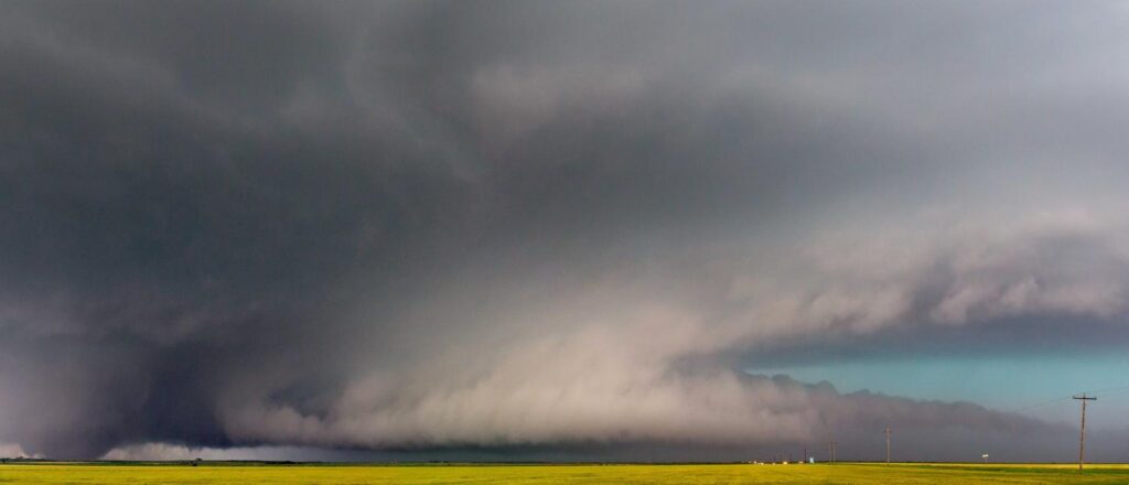
These low-level, horizontal, tail-shaped clouds extend from the main precipitation region of a supercell cumulonimbus cloud to the murus (wall cloud).

Their presence indicates strong convective activity and potential severe weather conditions.

Cauda Clouds
Cauda Clouds

Characteristics of Cauda Clouds

  • Base Altitude: Typically forms at low levels, extending horizontally from the main precipitation region of a supercell cumulonimbus cloud.
  • Top Altitude: The top of the cauda cloud is generally at the same height as the base of the murus (wall cloud), indicating a horizontal extension rather than vertical development.
  • Shape: Cauda clouds are horizontal, tail-shaped clouds that extend from the main precipitation region of a supercell cumulonimbus cloud to the murus (wall cloud).
  • Texture: The cloud may appear as a defined horizontal cloud band or as horizontally aligned cloud tags attached to the cumulonimbus murus cloud type.
  • Color: Typically appears darker due to the dense concentration of water droplets, but color can vary depending on lighting and atmospheric conditions.
  • Etymology: The term “cauda” is derived from the Latin word for “tail,” reflecting the cloud’s characteristic tail-like appearance extending from the wall cloud.
  • Precipitation: Cauda clouds themselves are not significant producers of precipitation. However, they are associated with the main precipitation region of a supercell cumulonimbus cloud, which can produce heavy rainfall and severe weather conditions.

Formation and Dynamics

Cauda clouds form in association with supercell thunderstorms, which are characterized by their rotating updrafts and well-defined structures.

The cauda cloud extends horizontally from the main precipitation region to the murus (wall cloud), indicating strong inflow of warm, moist air and significant convective activity.

The presence of a cauda cloud suggests that the storm is well-organized and has the potential to produce severe weather, including tornadoes.

Historical Context

The cauda cloud was officially recognized as a distinct cloud feature by the World Meteorological Organization (WMO) in the 2017 edition of the International Cloud Atlas. This addition highlighted the importance of recognizing and categorizing various cloud features associated with severe weather phenomena.

Cauda Clouds
Cauda Clouds

Observations and Phenomena

  • Severe Weather Indicator: The presence of a cauda cloud is a strong indicator of severe weather conditions, including the potential for tornadoes. Meteorologists closely monitor the development of cauda clouds to assess the severity of thunderstorms.
  • Visual Characteristics: Cauda clouds are often observed as horizontal, tail-shaped clouds extending from the main precipitation region of a supercell cumulonimbus cloud to the murus (wall cloud).

Distinguishing Cauda Clouds from Similar Cloud Forms

While cauda clouds share similarities with other cloud formations, they can be distinguished by their unique characteristics:

  • Flumen (Beaver’s Tail): Flumen clouds are larger inflow bands feeding into the updraft base of a storm and are typically higher in altitude compared to cauda clouds.
  • Wall Cloud (Murus): The murus (wall cloud) is a well-defined, vertically oriented cloud feature associated with severe thunderstorms. The cauda cloud extends horizontally from the murus, indicating a different orientation and structure.

Further Information

  • Geographic Distribution: Cauda clouds are observed in regions prone to supercell thunderstorms, including parts of the United States, Australia, and other areas with similar climatic conditions.
  • Scientific Research: Ongoing research aims to better understand the formation mechanisms and dynamics of cauda clouds, enhancing forecasting capabilities for severe weather events.
Tony S.
Tony is based in Australia and focuses on how false conspiracy theories spread and harm society, with an emphasis on clear facts and critical thinking.

Related

Stratus Clouds

Stratus are low, uniform cloud sheets often producing drizzle or mist. They form under stable, humid conditions with minimal uplift. The name has classical roots and features in everyday speech and literary descriptions of dull or overcast skies.

Fractus Clouds

Fractus clouds are small, irregular fragments that break away from larger cloud masses. They often form beneath precipitating clouds or along gust fronts, moving rapidly and constantly changing shape.

Cirrus Homogenitus Clouds (Contrails)

Cirrus homogenitus, more commonly known as contrails, are artificial ice clouds formed by aircraft exhaust in the upper troposphere and lower stratosphere. These streaks of vapour trail behind jet engines and resemble thin, fibrous cirrus clouds.

Lenticular Clouds

Lenticular clouds are smooth, lens-shaped formations that develop when stable, moist air flows over mountain ranges or obstacles. They are classified within the altocumulus or cirrocumulus genera

Cumulonimbus Clouds

Cumulonimbus are massive, convective, rain-producing clouds with substantial vertical extent and storm potential. They form in unstable, moist conditions and were formalised in cloud atlases; they appear frequently in art and storm literature.

Cirrus Clouds

Cirrus are high, ice-crystal, filamentous clouds forming in cold, moist upper tropospheric conditions. They act as harbingers of weather change. Named scientifically in the early 19th century by Luke Howard, they have long been used in art and poetry to evoke sky texture.

Featured

Counting the Cost of a Nationwide Chemtrail Programme

What would it actually take to run a nationwide US “chemtrail” operation? Our analysis reveals the staggering logistics — 165 aircraft, thousands of workers, and billions of dollars each year. The numbers tell their own story.

Why Contrails Can Linger and Spread

Contrails can linger and spread because they are essentially man-made cirrus clouds formed from ice crystals at high altitude. A cloud is made of water vapour, just like a contrail. Therefore if a cloud can linger, so can a contrail. When an aircraft’s hot exhaust mixes with cold, humid air, the resulting condensation freezes, creating thin white trails.

Cloud Seeding: You can’t Just Make Rain

It is impossible to manufacture rain, which depends on water vapour in the atmosphere. This is supplied by heat and evaporation from the Earth’s surface. Only when moist air cools and condenses into clouds is there potential for rain. Techniques such as cloud seeding cannot create this water; they can only encourage raindrops to form in clouds that are already primed to produce rain.

Why Humans Cannot Engineer Cyclones

Cyclones, hurricanes and typhoons are among the most powerful natural forces on Earth. Each one releases more energy in a few days than humanity consumes in years. Yet online theories claim that human technology, such as HAARP or directed electromagnetic fields (EMF), could somehow create or steer these vast systems.

The Logistics of Secrecy: The Impossible Scale of a Chemtrail Programme

This article examines the chemtrail conspiracy through physics, engineering, and economics. It shows that a nationwide spraying programme would require hundreds of aircraft, thousands of staff, and billions in funding—leaving clear evidence. The science of contrails fully explains the phenomenon without invoking any secret aerosol operation.

The chemtrail conspiracy would collapse within a few years

Physicist David Grimes’s 2016 mathematical model shows that large conspiracies such as Chemtrails inevitably unravel through leaks. His analysis demonstrates that a secret global spraying programme involving thousands of people over decades is statistically implausible.

Popular Categories