

Overview of Lenticular Clouds
Lenticular clouds are smooth, lens-shaped formations that develop when stable, moist air flows over mountain ranges or obstacles.
They are technically classified within the altocumulus or cirrocumulus genera depending on height and composition.
Lenticulars are wave clouds, forming at the crest of lee waves where air rises, cools to saturation, and then descends.
Their persistence indicates stable stratification and continuous moisture supply. Radar and lidar observations show that their vertical thickness is typically 300 to 600 metres, with microphysical properties shifting from supercooled water to ice depending on temperature.
The mountain-wave dynamics that generate lenticulars are also associated with turbulence, which is why pilots often avoid their vicinity despite their beauty.
Details
Height: Bases from 6,500 to 20,000 feet (2,000–6,000 metres), occasionally higher.
Look: Stationary, lens-like, often layered with iridescent edges.
Name meaning: From Latin lenticularis, meaning “lens-shaped.”
Rain: Rarely produce precipitation; typically dry.
What Do Lenticular Clouds Look Like
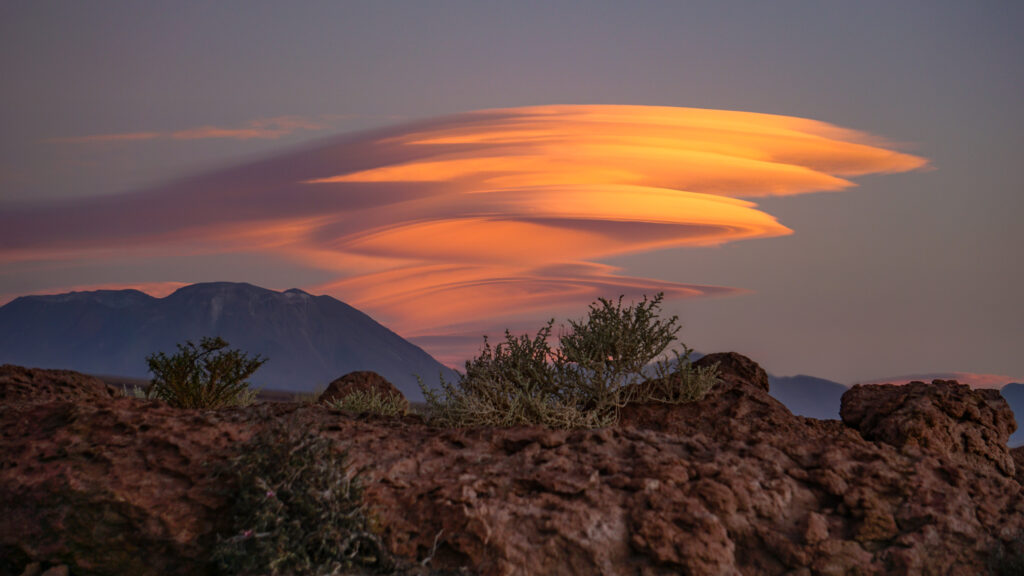
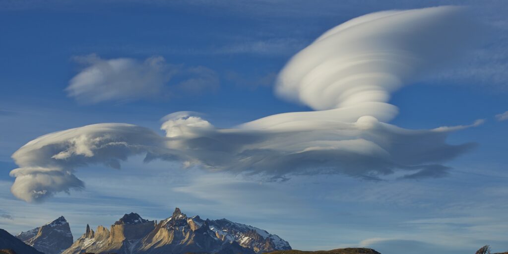
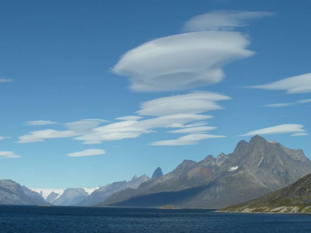
Lenticular clouds often resemble flying saucers or stacks of pancakes, sharply contoured and immobile despite strong winds aloft.
They can display colourful fringes known as irisation, caused by diffraction of sunlight through uniform ice crystals or water droplets.
At sunset, their edges glow with spectacular hues of red and gold.
A History of Lenticular Clouds
Luke Howard’s early 19th-century cloud classification did not originally include lenticulars as a separate type.
Their identification as a distinct form came in the late 1800s through the observations of mountain meteorologists in the Alps and Andes.
Pilots of early gliders in the 1930s quickly recognised lenticular clouds as indicators of strong standing waves, allowing them to exploit updrafts for extended flight.
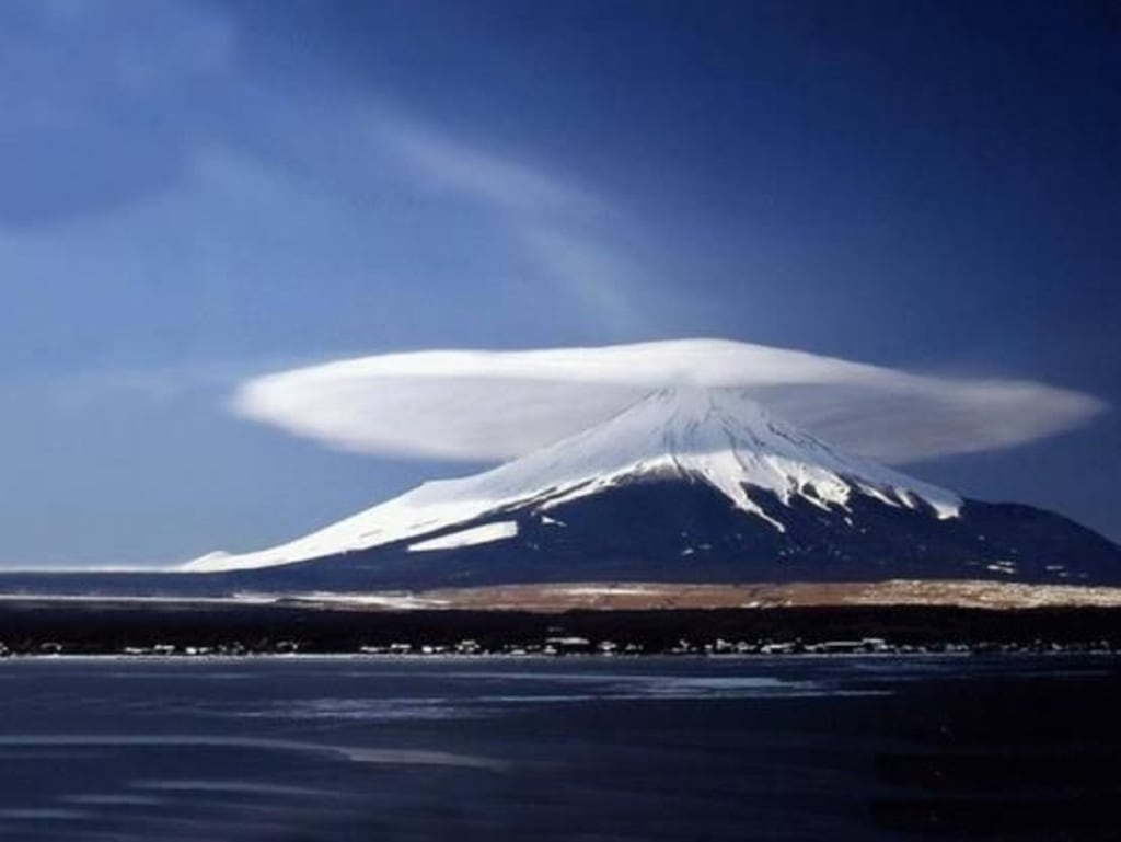
How Lenticular Clouds Form
Orographic Forcing and Initial Ascent
The formation of lenticular clouds begins when a steady, moist air mass encounters elevated terrain. Unable to pass through the obstacle, the air is forced upward, cooling adiabatically as it rises. If the air reaches the dew point, water vapour condenses to form cloud droplets.
Unlike many clouds, lenticular clouds do not typically form directly over mountain summits. Instead, they develop downstream, where air undergoes vertical oscillations after crossing the ridge.
This oscillation, known as a mountain wave, provides the necessary structure for lenticular cloud formation.
Atmospheric Stability and Wave Dynamics
Mountain waves require a stably stratified atmosphere, where vertical displacements of air generate oscillatory motion rather than convective overturning.
As air descends beyond the crest, it warms, overshoots its equilibrium level, and rises again, establishing a vertical oscillation.
The rate of these oscillations is quantified by the Brunt–Väisälä frequency, which determines how quickly displaced air parcels return to their original level. In the lower troposphere, oscillation periods are typically five to ten minutes.
These standing waves remain fixed relative to the terrain, even though the air itself continues to move horizontally.
Condensation and Cloud Formation
Within a mountain wave, alternating regions of upward and downward motion occur. In the rising portions, air cools, reaches saturation, and condenses to form cloud droplets. In the descending portions, warming air causes evaporation.
This continuous process, condensation on the upwind side and evaporation on the downwind side, gives lenticular clouds their stationary appearance.
While the air moves through the wave, the visible condensation region remains fixed, producing the distinctive lens shape.
Atmospheric Conditions Required
Several factors must align for lenticular clouds to form:
- Stable air layers: The vertical temperature gradient must resist large-scale convection but allow oscillation.
- Adequate moisture: Relative humidity near 100% at the wave crest is essential for condensation.
- Strong, steady winds: Typically 20–25 m/s (70–90 km/h), blowing nearly perpendicular to the mountain ridge.
- Terrain geometry: Smooth, elongated ridges produce coherent waves, whereas irregular peaks disrupt them.
When these conditions persist, lenticular clouds can remain visible for hours or even longer.
Vertical Structure and Multiple Layers
Atmospheric waves often produce multiple crests at different altitudes. If moisture is present at each crest, several stacked lenticular clouds can form.
The horizontal and vertical spacing of these layers depends on wind speed and atmospheric stability. Using the relation λ = 2πU/N, where U is wind speed and N is Brunt–Väisälä frequency, typical mountain waves have wavelengths around 10 kilometres, producing spaced cloud layers with vertical separations of 1–2 kilometres.
Formation Beyond Mountains
While mountains are the primary trigger, lenticular clouds can also form above temperature inversions or frontal boundaries.
In these cases, stable airflow is displaced similarly, producing standing waves that generate condensation layers. The physical mechanism remains identical across orographic and non-orographic settings.

