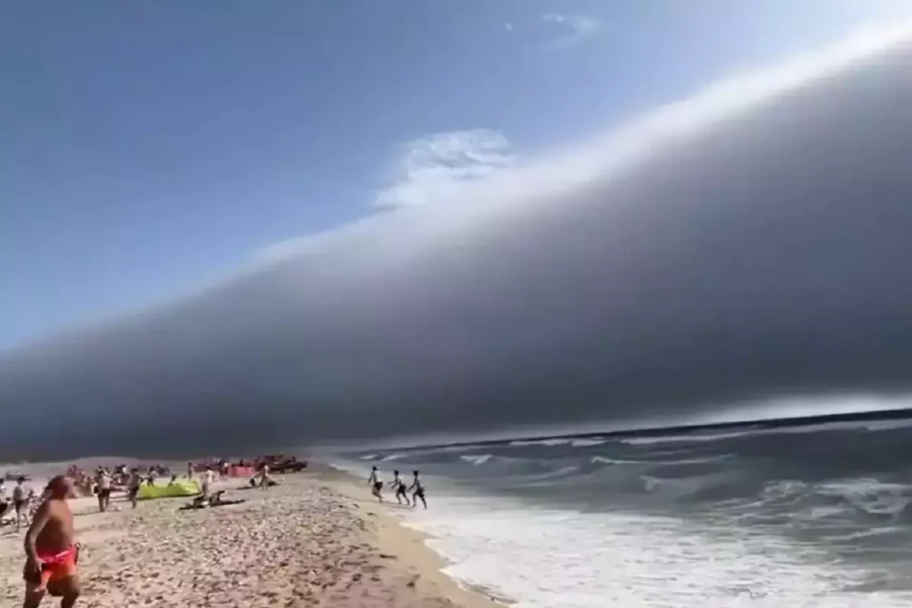
Volutus clouds, commonly known as roll clouds, are a type of Arcus Cloud. They are rare, low-level cloud formations characterized by their distinctive tube-like shape and horizontal orientation.
They typically appear detached from other cloud systems and exhibit a rolling motion along a horizontal axis.
These clouds are most commonly associated with the stratocumulus genus but can occasionally be observed in altocumulus formations.
Their unique structure and behavior make them a subject of interest for meteorologists and cloud enthusiasts alike.

Characteristics of Volutus Clouds
- Base Altitude: Volutus clouds generally form at low altitudes, with bases typically below 2,000 meters (6,600 feet) above sea level.
- Top Altitude: The tops of these clouds are usually not well-defined, as they often blend seamlessly with the surrounding atmosphere.
- Shape: Volutus clouds present a long, horizontal, tube-shaped mass that can extend across the sky. They often appear to roll slowly about a horizontal axis, giving them their characteristic “rolling” appearance.
- Texture: The surface of a volutus cloud can vary from smooth and silky to rough and bumpy, depending on the atmospheric conditions at the time of formation.
- Color: These clouds are typically white or light gray, but their color can change based on the angle of the sun and the time of day.
- Etymology: The term “volutus” is derived from the Latin word “volvĕre,” meaning “to roll” or “to revolve.” This name aptly describes the cloud’s rolling motion and appearance.
- Precipitation: Volutus clouds are generally not associated with significant precipitation. However, they may produce brief, light showers, especially if they form in association with other weather systems.
Formation and Dynamics
Volutus clouds are a type of soliton, a solitary wave that maintains its shape while traveling at constant speed.
They are an example of an undular bore, a type of gravity wave that propagates through a stably stratified fluid.
These clouds form when differences in wind speed and direction between the surface and higher altitudes (wind shear) create a rolling motion in the atmosphere.
This rolling motion leads to the formation of a low-level, detached cloud mass that exhibits the characteristic tube shape.
Morning Glory Clouds
Morning Glory clouds are one of the most spectacular and well-documented examples of volutus clouds.
They appear as long, rolling, tube-shaped clouds that can stretch for hundreds of kilometres, moving steadily across the sky.
These clouds form under very specific atmospheric conditions, usually involving stable low-level air, a shallow inversion layer, and converging sea breezes.
The classic location for observing this phenomenon is over the Gulf of Carpentaria in Northern Queensland, Australia, where it occurs most frequently in September and October.
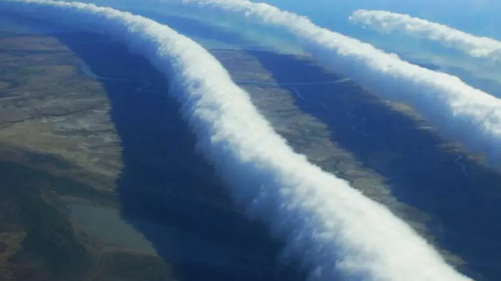
The rolling motion of Morning Glory clouds is caused by a solitary wave, or undular bore, in the lower atmosphere.
This wave propagates along a horizontal axis, lifting the air at the front of the wave and creating the characteristic tube shape.
Unlike typical arcus clouds, these clouds are completely detached from other cloud systems, making them true volutus formations.
Morning Glory clouds are not only a visual spectacle but also of interest to glider pilots, who can use the rising air created by the rolling wave to gain altitude.
They are generally low-level clouds, with bases around 100 to 1,500 metres, and do not produce significant precipitation, though light drizzle is occasionally observed.
This phenomenon highlights the dynamic complexity of volutus clouds and demonstrates how specific geographic and meteorological conditions can produce rare and dramatic cloud forms.
Historical Context
The volutus cloud was officially recognized as a distinct cloud species by the World Meteorological Organization (WMO) in 2017. Prior to this, roll clouds were often classified under general cloud types without specific designation.
The inclusion of volutus in the WMO’s International Cloud Atlas marked a significant update, being the first new cloud species added in over 30 years.
Observations and Phenomena
- Morning Glory Cloud: One of the most famous examples of a volutus cloud is the Morning Glory cloud observed over the Gulf of Carpentaria in Northern Queensland, Australia. This phenomenon occurs when sea breezes from different directions converge, creating the conditions necessary for the formation of a volutus cloud.
- Glider Piloting: The rolling motion of volutus clouds can create areas of rising air, known as lift, which glider pilots can utilize to gain altitude. This makes volutus clouds of particular interest to the gliding community.
Distinguishing Volutus Clouds from Arcus Clouds
Volutus clouds are considered a species within the broader arcus cloud category, but with a specific distinction. Here’s the technical breakdown:
- Arcus clouds are low, horizontal, cloud formations that appear as accessory clouds—usually forming along the leading edge of a thunderstorm or along a cold/warm front. They include shelf clouds and roll clouds.
- Volutus clouds are a detached, rolling tube-shaped cloud, which is why they are classified as a species of stratocumulus (or sometimes cumulus) clouds but fall under the arcus accessory cloud type in terms of morphology.
- The key distinction is that most arcus clouds (like shelf clouds) are attached to a parent cloud system, whereas volutus clouds are usually fully detached, rolling independently along a horizontal axis.
So, in short: all volutus clouds are arcus clouds, but not all arcus clouds are volutus clouds.

Further Information on Volutus Clouds
- Geographic Distribution: Volutus clouds are relatively rare and can be observed in various parts of the world. Their formation is influenced by local atmospheric conditions, including wind patterns and temperature gradients.
- Scientific Research: Researchers continue to study volutus clouds to better understand their formation mechanisms and the atmospheric conditions that lead to their development.
Volutus clouds are a fascinating and rare atmospheric phenomenon that showcases the dynamic nature of Earth’s weather systems.
Their unique rolling motion and formation process provide valuable insights into atmospheric dynamics and cloud formation.
Continued observation and study of these clouds will enhance our understanding of the complex interactions within the Earth’s atmosphere.