
Overview of Arcus Clouds
Arcus clouds are dramatic, low-level horizontal cloud formations that appear along the leading edges of thunderstorms or gust fronts. They occur in two principal forms: shelf clouds and roll clouds.

Arcus clouds mark boundaries between contrasting air masses. Warm, moist air is lifted over a cold outflow, producing condensation at the leading edge.
Doppler radar and lidar studies show intense turbulence within shelf clouds, with updrafts exceeding 10 m/s.
Roll clouds often form through solitary wave dynamics, where stable stratification allows an undulating motion to propagate without significant dissipation.
Details
Height: Bases typically between 1,000 and 6,000 feet (300–2,000 metres).
Look: Long, horizontal, rolling or shelf-like structures ahead of storm fronts.
Name meaning: From Latin arcus, meaning “arch” or “bow.”
Rain: Usually precede heavy rain, wind gusts, or hail.
What Do Arcus Clouds Look Like
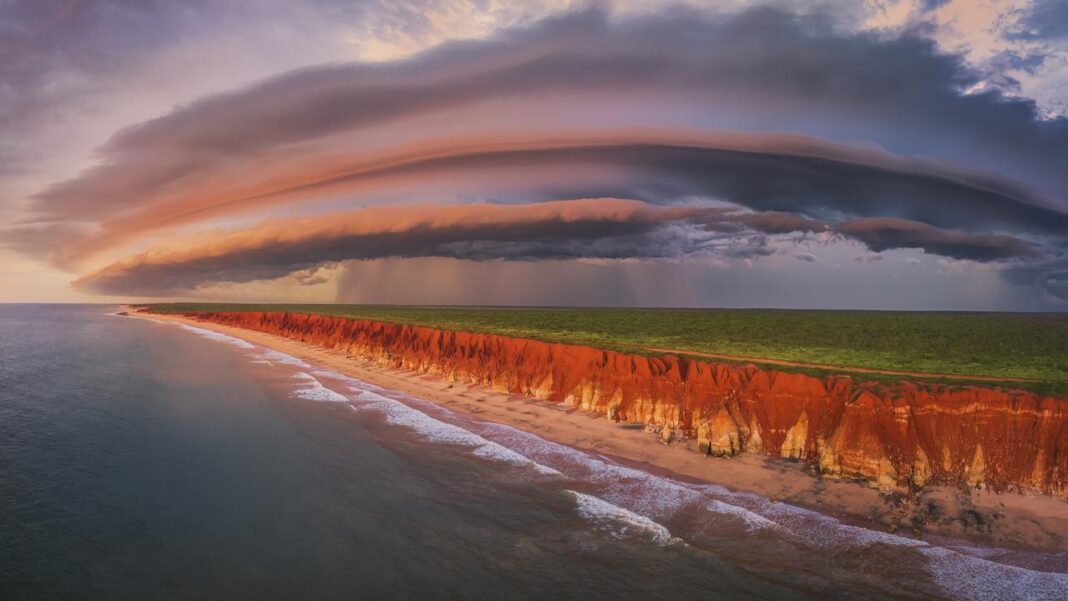
Arcus clouds can span the horizon, appearing as dark, turbulent waves preceding an approaching squall.
Shelf clouds are attached to the thunderstorm base and exhibit rising motion at the front edge and descending motion at the rear.
Roll clouds, by contrast, are detached, cylindrical, and often rotate around a horizontal axis. Both forms can produce striking visual effects, particularly when lit by sunrise or sunset.
Types of Arcus Clouds
Roll Clouds

Roll clouds are detached horizontal tubes, often extending for tens of kilometres. They may rotate slowly but do not produce tornadoes.
The physics involves Kelvin–Helmholtz instabilities and gravity wave interactions.
Their rare occurrence makes them prized targets for photographers and meteorologists alike.

Morning Glory Clouds (The Australian Roll Cloud)
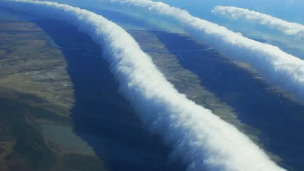
The Morning Glory is a unique type of roll cloud observed across the Gulf of Carpentaria, Australia, primarily between September and November.
Stretching up to 1,000 kilometres in length and moving at speeds near 60 km/h, it is part of a soliton wave generated by interactions between sea breezes and the Cape York Peninsula’s terrain.
The phenomenon was first systematically studied by the Royal Australian Air Force in the 1970s, with aircraft and glider measurements confirming its wave dynamics.
The cloud forms in a stable boundary layer, with moist air rising along the leading edge of the wave, producing a continuous rolling cloud that can last for hours.
It remains one of the most visually stunning and scientifically significant examples of mesoscale atmospheric waves.
Shelf Clouds
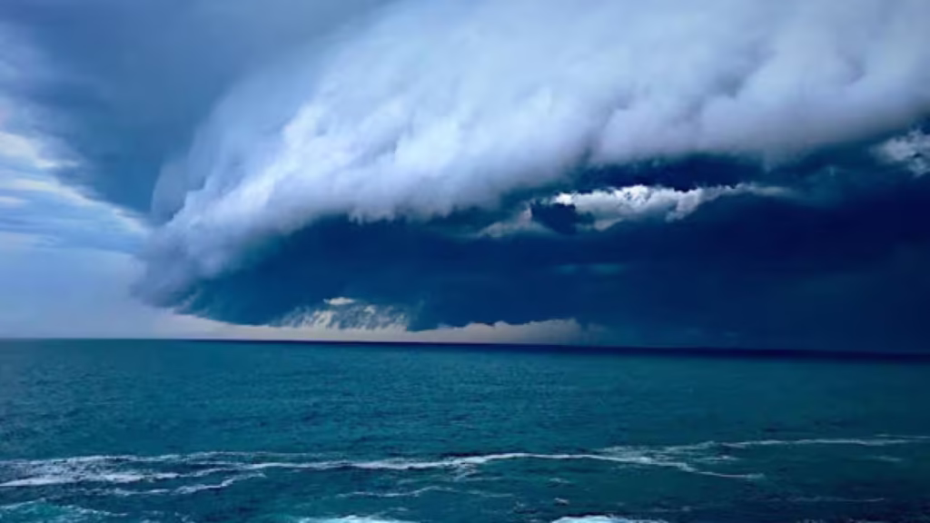
Shelf clouds remain attached to the storm base and signal advancing downdrafts.
Their ragged lower edges and dynamic motion are caused by condensation and evaporation cycles.
Shelf clouds are frequently mistaken for wall clouds, but unlike wall clouds, they do not indicate tornadic rotation.
Distinguishing Arcus Clouds Volutus Clouds
Volutus clouds are considered a species within the broader arcus cloud category, but with a specific distinction. Here’s the technical breakdown:
- Arcus clouds are low, horizontal, cloud formations that appear as accessory clouds—usually forming along the leading edge of a thunderstorm or along a cold/warm front. They include shelf clouds and roll clouds.
- Volutus clouds are a detached, rolling tube-shaped cloud, which is why they are classified as a species of stratocumulus (or sometimes cumulus) clouds but fall under the arcus accessory cloud type in terms of morphology.
- The key distinction is that most arcus clouds (like shelf clouds) are attached to a parent cloud system, whereas volutus clouds are usually fully detached, rolling independently along a horizontal axis.
So, in short: all volutus clouds are arcus clouds, but not all arcus clouds are volutus clouds.
How do Arcus Clouds Form

Formation of Roll Clouds
Roll clouds form as a result of horizontal wind shear combined with the movement of a stable layer of moist air over a boundary of differing temperature or pressure.
They develop along the leading edge of a thunderstorm outflow or a cold front.
When cool, dense air from a downdraft or advancing front spreads out along the ground, it undercuts the warmer, moist air ahead of it.
As this warmer air is lifted, it cools and condenses, creating a long, tube-like cloud parallel to the frontal boundary.
The process depends on a balance between wind speed, temperature contrast, and moisture content: too little shear or moisture and the roll cloud will not form, while excessive turbulence will tear it apart before it becomes organised.
Once formed, roll clouds are sustained by a self-contained circulation, with air rising at the front, cooling and condensing at the crest, then descending and evaporating at the rear.
This horizontal rotation gives the cloud its characteristic rolling motion, which can look like a vast rotating cylinder stretched across the horizon.
Unlike shelf clouds, roll clouds are not attached to a storm base and can travel independently for many kilometres.
They are often observed along sea breezes, coastal fronts, or outflow boundaries, such as the famous Morning Glory cloud of northern Australia.
Their striking form serves as a visible demonstration of boundary-layer wind dynamics and the delicate interplay between moisture, stability, and shear in the lower atmosphere.
Formation of Shelf Clouds
Shelf clouds form along the leading edge of a thunderstorm or strong convective system, often appearing as a low, horizontal wedge stretching across the sky.
They develop when a downdraft of cool, dense air from the storm spreads outward and lifts the warmer, moist air ahead of it.
As this warm air rises, it cools to its dew point, and condensation occurs, creating a dramatic, often turbulent-looking cloud base.
The distinctive “shelf” shape results from the turbulent mixing at the interface between the outflow and the surrounding air, with rising currents feeding the upper portion of the cloud while descending air causes the lower edge to appear ragged or scrolled.
Shelf clouds often signal the approach of strong winds, heavy rain, or gust fronts, making them an important visual indicator of storm activity.
A History of Arcus Clouds
Arcus formations were noted in early meteorological literature describing squall lines and gust fronts.
The International Cloud Atlas (1956 edition) formally adopted the term. Roll clouds became famous due to their rare and dramatic appearances along coastal regions, especially the Morning Glory phenomenon in northern Australia.
History of Shelf clouds
Arcus clouds, or shelf clouds, have been recognized visually and documented informally for centuries, with systematic classification of clouds beginning in the early 19th century with Luke Howard’s work, though the term “arcus” was not formally integrated into the modern WMO cloud atlas until later as a type of accessory cloud.
Early Observation: While shelf clouds have been observed and photographed for a long time, formal documentation and naming were not part of early cloud classification schemes.
Modern Classification: The modern system for classifying clouds was established by Luke Howard in 1803, but this initial system focused on the three main types: cirrus, stratus, and cumulus, with additional forms like nimbus.
History of Roll Clouds
Arcus (or roll) clouds were not a distinct, officially documented cloud type until recently, though they have been observed for centuries and were described in various contexts, including by William Clement Ley in 1894.
The specific “Morning Glory” roll clouds were well-known in Australia and documented in scientific literature in the early 20th century, with more widely recognized images and scientific interest growing in the 2000s.
Modern Documention and Recognition
- 2000s: Images and observations of roll and arcus clouds, including the Morning Glory, became more common and widespread during this period due to digital photography and the internet.
- Official Recognition: The International Cloud Atlas of the World Meteorological Organization is where many cloud types are formally cataloged. While arcus clouds have been recognized for a long time, a specific cloud feature called Asperitas (a wave-like cloud) was only added as a supplementary feature in 2017, 15 years after its initial proposal.
History of Morning Glory Clouds
Morning Glory clouds in the Gulf of Carpentaria were first documented in an Australian weather officer’s notes between 1937 and 1939, but the earliest known published description is in a 1942 Royal Australian Air Force publication.
Local Garrawa Aboriginal people were aware of the clouds much earlier, calling them “kangolgi”.
Early Observations
- 1937-1939: R.V. Deering, a Weather Officer at Karumba, recorded observations of the phenomenon in his notes.
- 1935: A slightly earlier account of an observation was given in a biography of R.D. Gallop, an engineer who supervised the construction of a causeway near Augustus Downs, according to Meteorologie – LMU München.
First Published Account
- 1942: The earliest known published description appeared in the Royal Australian Air Force (RAAF) Publication No. 242, which was based on Deering’s notes.
Scientific Study
- The phenomenon was largely unknown to scientists until the early 1970s, when researchers from the University of Melbourne, led by Reg H. Clarke, began studying it.
- The first studies proposed that the Morning Glory could be interpreted as a type of internal atmospheric bore.

