

Overview of Pileus Clouds
Pileus clouds, often called cap clouds, form as thin, smooth layers over the tops of rapidly growing cumulus or cumulonimbus towers. They signify vigorous updrafts and rapid vertical development in convective systems.

Details
Height: Generally 20,000–40,000 feet (6,000–12,000 metres) for cumulonimbus-associated types, lower for cumulus.
Look: Smooth, silky cap or veil draped over cloud tops.
Name meaning: From Latin pileus, meaning “cap” or “skullcap.”
Rain: None directly; may precede heavy showers from parent cumulonimbus.
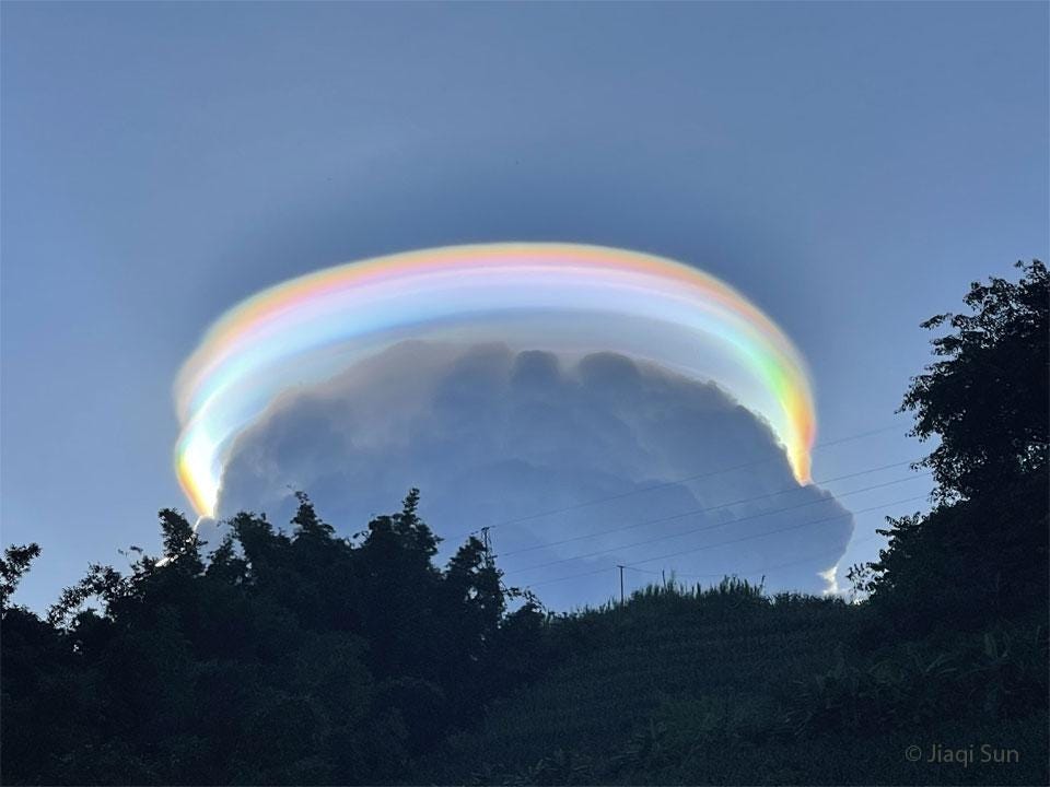
What Do Pileus Clouds Look Like
Pileus clouds resemble translucent domes resting atop the cauliflower structure of cumulus towers. As the underlying cloud rises, the pileus may be engulfed or displaced upward.
When illuminated by the sun, pileus clouds sometimes display iridescence, with pastel greens, pinks, and violets caused by diffraction through small water droplets.
A History of Pileus Clouds
Luke Howard’s classification in 1803 did not mention pileus explicitly, but later observers like Ralph Abercromby and Hugo Hildebrandsson included them in their cloud atlases of the late 19th century.
Pileus features became a subject of meteorological photography during the early 20th century as cameras captured the fleeting structures above growing thunderstorms.
Further Information
Pileus formation occurs when moist air is lifted over an updraft dome, reaching saturation and forming a condensation layer.
Radiosonde data show that pileus clouds often mark levels of strong stability or humidity.
Their presence indicates that the convective plume is rising rapidly through a moist layer, often preceding the onset of severe convection.
Observers regard pileus as transient but valuable indicators of storm intensification.

