

Introduction to The 4 Core Types of Clouds
The modern understanding of clouds owes much to the early work of Luke Howard, who in 1803 introduced a systematic method for describing and naming them.
His classification, though based on appearance rather than measurement, remains the foundation of cloud taxonomy.
Howard recognised that clouds could be grouped into four primary forms; cirrus, cumulus, stratus, and nimbus. Each represents a distinct type of atmospheric motion and moisture behaviour.
Today, meteorologists continue to use these four fundamental types as the basis of the World Meteorological Organization’s (WMO) system.
They form the roots of the ten principal cloud genera, which are grouped by height into high-, mid-, and low-level clouds, along with those exhibiting vertical development.
Yet beneath this structural complexity, the essence of Howard’s system endures. Each core type reflects a unique physical process that defines the structure, altitude, and weather associated with it.
Cirrus Clouds: The Curl of the Upper Troposphere
Types of Cirrus Cloud
-
Cirrostratus Clouds

Cirrostratus are high, veil-like ice-crystal clouds that spread diffusely and often produce halos around the sun or moon. They form under gentle ascent near warm fronts. Their name solidified in standard cloud atlases from the late 19th century, and they feature in halo folklore.
-
Cirrocumulus Clouds

Cirrocumulus are small, finely textured clouds of ice crystals in a high layer, appearing as ripples or patchwork. They form under weak vertical motion. The term was formalised in 19th-century cloud atlases, and the “mackerel sky” phrase has long circulated in folk weather lore.
-
Cirrus Clouds
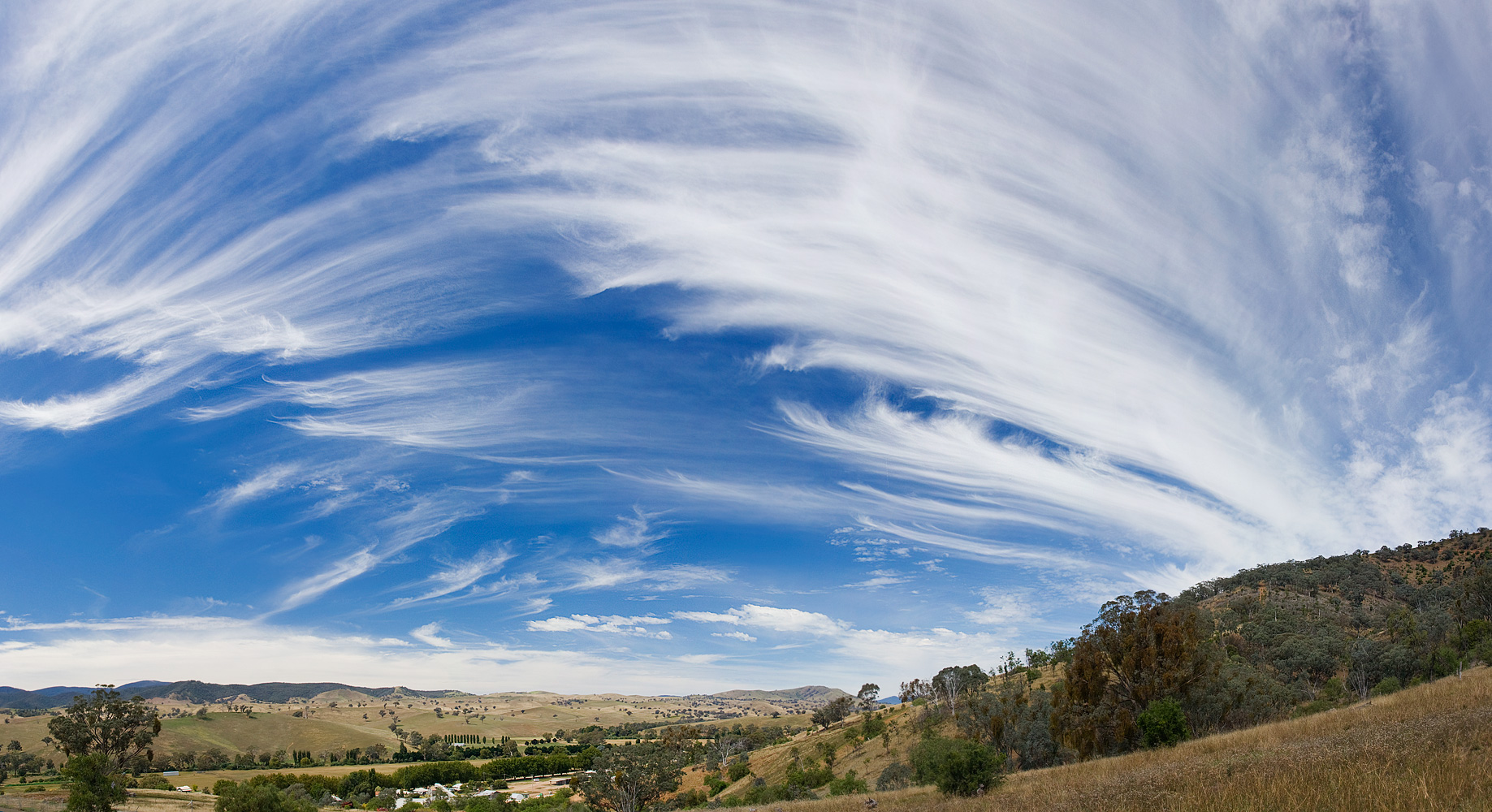
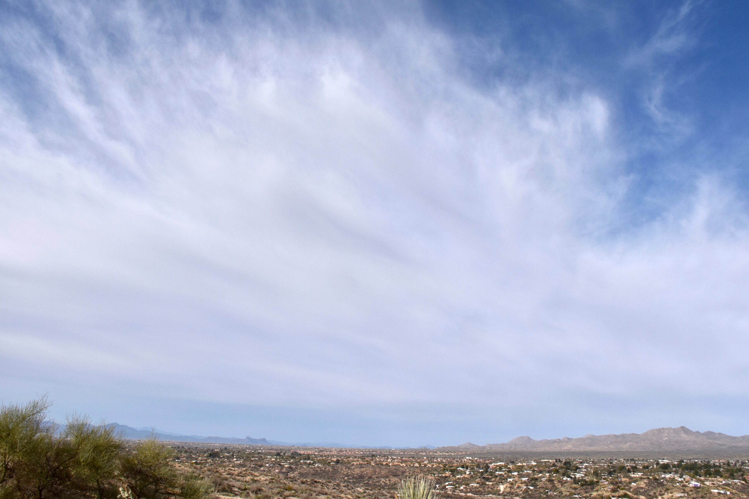
Cirrus are high, ice-crystal, filamentous clouds forming in cold, moist upper tropospheric conditions. They act as harbingers of weather change. Named scientifically in the early 19th century by Luke Howard, they have long been used in art and poetry to evoke sky texture.
Formation and Composition
Cirrus clouds are the highest and most delicate of the four core types. They form at altitudes between 6,000 and 13,000 metres, often within the upper troposphere or even near the tropopause. At these altitudes, temperatures are typically below –40°C, so cirrus clouds consist entirely of ice crystals.
They develop where moist air is lifted gradually and cooled to saturation, usually by large-scale ascent along fronts, outflow from tropical convection, or the vertical motion associated with jet streams.
As water vapour deposits directly onto ice nuclei, it forms long, fibrous streaks that may stretch across vast areas of the sky.
Appearance and Structure
Cirrus clouds are thin, white, and wispy, often arranged as filaments, hooks, or streaks. Their fine texture results from strong upper-level winds that stretch the ice crystals into streamers aligned with the airflow.
Common varieties include cirrus fibratus, consisting of delicate fibres, and cirrus uncinus, which display hooked or comma-shaped ends that trail downward as ice particles sublimate.
These clouds do not obscure sunlight, producing only a faint veil across the sky. At sunrise or sunset, the ice crystals can refract light into subtle halos or coloured arcs.
Meteorological Significance
Cirrus clouds often precede warm or occluded fronts by a day or more, marking the approach of large-scale weather systems.
Their appearance indicates moisture and instability entering the upper troposphere. When cirrus thickens and lowers, it may evolve into cirrostratus, a precursor to mid-level and eventually precipitating clouds.
Because they reflect incoming sunlight while allowing infrared radiation to escape, cirrus clouds exert a complex influence on the Earth’s radiation balance.
Their optical thickness, altitude, and ice crystal size all determine whether they have a net warming or cooling effect on climate.
Historical Context
Howard’s term cirrus, meaning “curl” in Latin, referred to their hair-like form. His observations of cirrus movement provided early insight into upper-air currents, long before direct measurements became possible.
Modern satellite imagery now reveals their vast scale, showing that cirrus bands often stretch thousands of kilometres, tracing the flow of jet streams and tropical outflow.
Cumulus Clouds: The Heaped Clouds of Convection
Types of Cumulus Clouds
-
Stratocumulus Clouds
Stratocumulus are low, clustered, lumpy cloud layers that bridge the gap between stratus and cumulus. They form via shallow convection and mixing. Their name arose from 19th- and 20th-century cloud taxonomy, and they are familiar in weather forecasts and landscape art.
-
Altocumulus Clouds
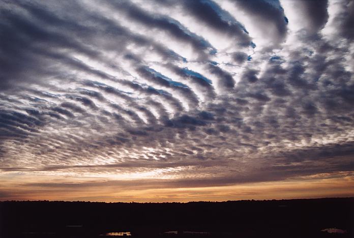
Altocumulus are mid-level, patchy, somewhat convective clouds forming in moist layers with slight instability. They often show patterns or grouping. Their name originated in the 19th-century expansion of cloud classification, though clouds of this sort were long observed in art and literature.
-
Cumulus Clouds
Cumulus are low, puffed, convective clouds formed by surface heating and uplift. They have flat bases and variable tops. The name was coined in the early 19th century and is widely familiar in art, and literature.
-
Cirrocumulus Clouds
Cirrocumulus are small, finely textured clouds of ice crystals in a high layer, appearing as ripples or patchwork. They form under weak vertical motion. The term was formalised in 19th-century cloud atlases, and the “mackerel sky” phrase has long circulated in folk weather lore.
-
Cumulonimbus Clouds
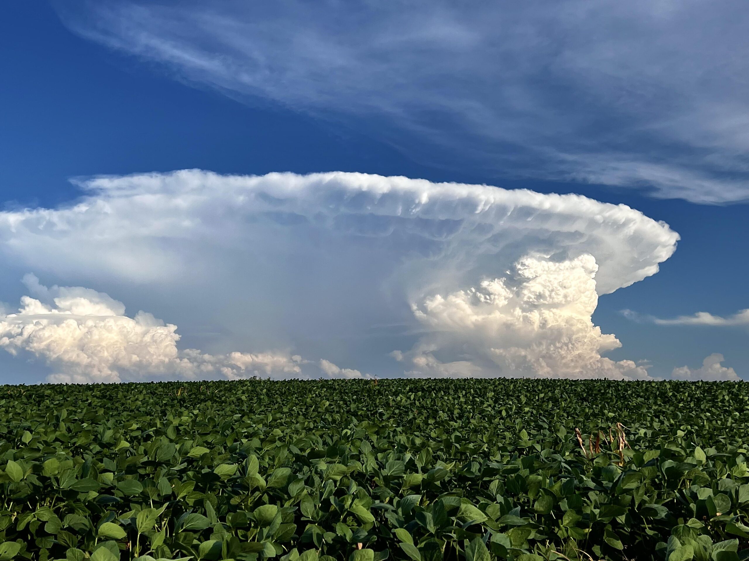
Cumulonimbus are massive, convective, rain-producing clouds with substantial vertical extent and storm potential. They form in unstable, moist conditions and were formalised in cloud atlases; they appear frequently in art and storm literature.
Formation and Dynamics
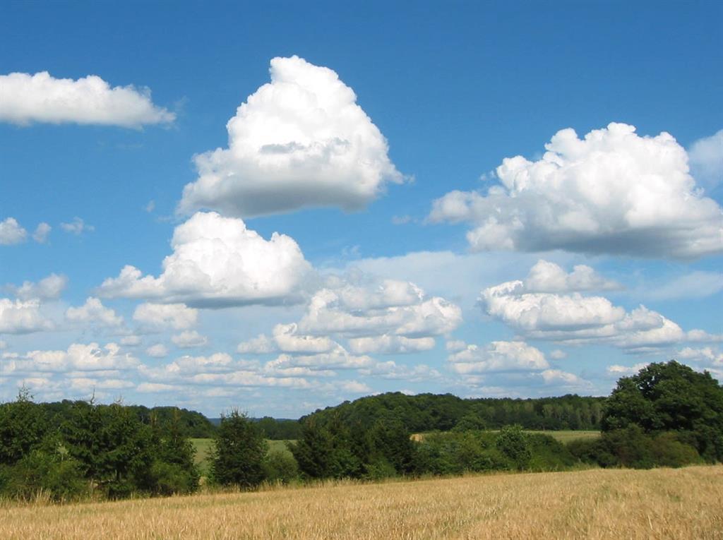
Cumulus clouds are the most recognisable of all cloud forms; large, white heaps rising against the blue sky.
They develop through convective processes in which pockets of warm, moist air rise from the surface, expand, and cool adiabatically until condensation occurs. The base of a cumulus marks the lifting condensation level, where the air first becomes saturated.
Typical cumulus bases occur between 1,000 and 2,500 metres, though they vary with temperature and humidity.
As the rising air continues to cool, the cloud can expand upward several kilometres, forming towering cumulus when the atmosphere is unstable.
Appearance and Structure
Cumulus clouds have flat bases and sharply defined, rounded tops. The tops often resemble cauliflower heads, shaped by the continuous motion of rising and descending air within the cloud.
The upper surfaces are bright white in sunlight, while the bases appear darker due to shadow and density.
As convection strengthens, cumulus clouds may merge or grow vertically into cumulus congestus, and eventually into cumulonimbus, the classic thunderstorm cloud.
This progression represents a transition from shallow convection to deep, vigorous updrafts capable of producing precipitation, lightning, and turbulence.
Meteorological Significance
Cumulus clouds are indicators of thermal convection and local atmospheric instability. Small, scattered cumulus suggest fair weather, as their vertical extent is limited by a stable layer aloft.
When the atmosphere is unstable through a deep layer, they can signal the onset of convective storms.
In tropical and subtropical regions, cumulus clouds are central to the daily weather cycle, forming as the surface warms during the day and dissipating as it cools at night.
Their role in vertical heat and moisture transport makes them critical to understanding energy balance and rainfall formation.
Historical Context
The name cumulus derives from the Latin for “heap” or “pile,” reflecting the clouds’ massive, piled-up appearance.
Howard’s description of cumulus as “the least changeable of the modifications” captured their relatively stable outlines compared with the transient forms of cirrus and stratus.
Yet the cumulus cloud’s dynamism, continuously forming and dissipating, became one of the first visual examples of the atmosphere as a fluid system in motion.
Stratus Clouds: The Layered Veil of the Lower Troposphere
Types of Stratus Clouds
-
Cirrostratus Clouds
Cirrostratus are high, veil-like ice-crystal clouds that spread diffusely and often produce halos around the sun or moon. They form under gentle ascent near warm fronts. Their name solidified in standard cloud atlases from the late 19th century, and they feature in halo folklore.
-
Nimbostratus Clouds
Nimbostratus are thick, opaque, precipitating layers of cloud that produce steady rain or snow. They form in broad lift regions and may span much vertical depth. The name comes from later refinements to Howard’s schema and serves as a core genus in modern meteorology.
-
Stratus Clouds

Stratus are low, uniform cloud sheets often producing drizzle or mist. They form under stable, humid conditions with minimal uplift. The name has classical roots and features in everyday speech and literary descriptions of dull or overcast skies.
-
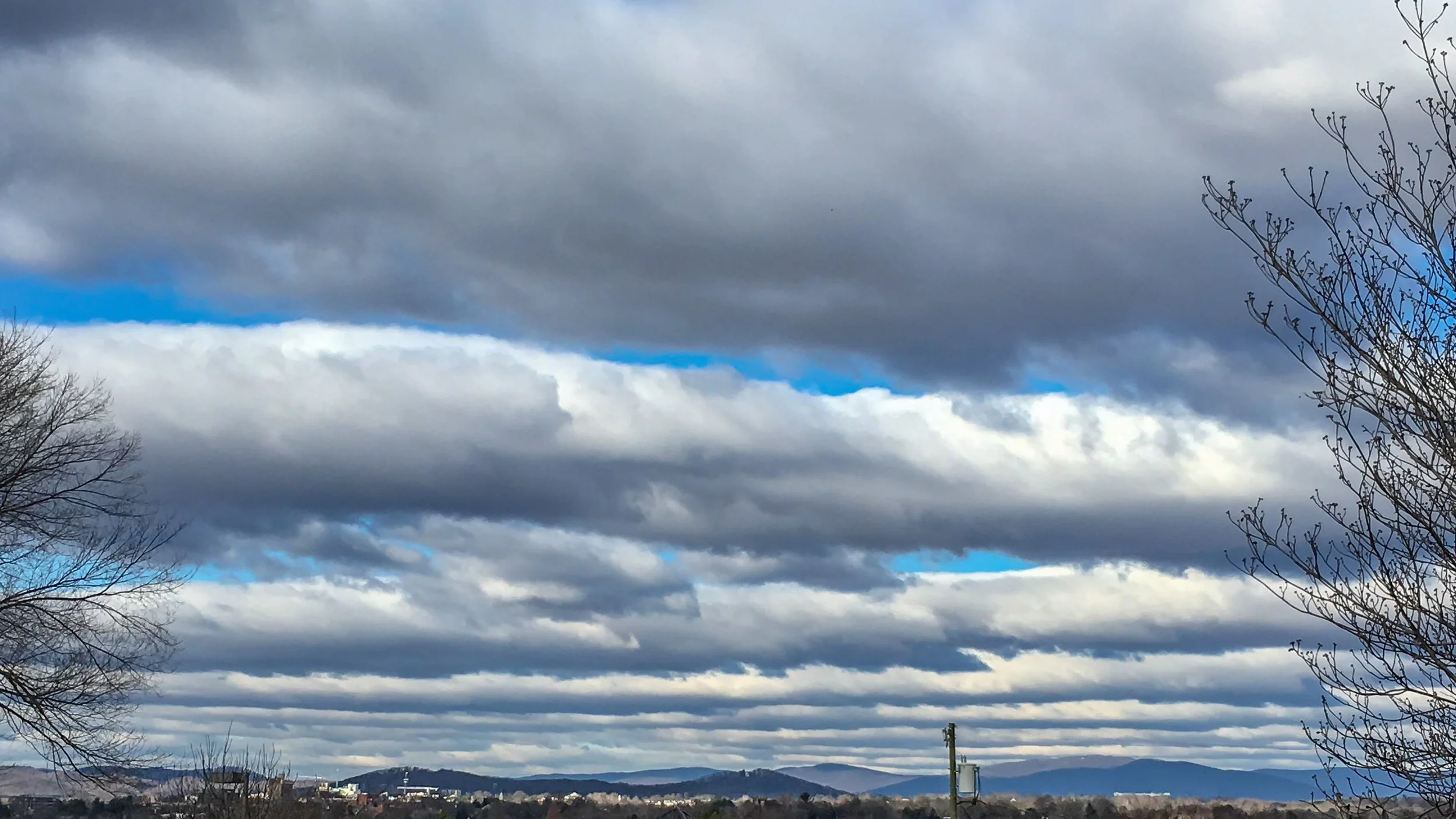
Altostratus Clouds
Altostratus are mid-level, uniform grey sheets that often cover the sky and may dim sunlight or bring light precipitation. They are created by gentle lifting of moist air and were formally classified during the development of modern cloud atlases.
Formation and Composition
Stratus clouds form in the lowest layers of the atmosphere, typically from the surface up to about 2,000 metres.
They develop when a layer of air is lifted gently, cooled, and saturated, producing a uniform sheet of cloud that can cover the entire sky.
This process is often associated with temperature inversions, marine air advection, or radiative cooling overnight.
Unlike cumulus, which form from vertical motion, stratus clouds result from horizontal spreading of moist air.
Their droplets are small, and the clouds are usually thin and featureless, composed mainly of liquid water.
Appearance and Structure
Stratus clouds appear as a uniform, grey layer with diffuse edges, often producing dull, overcast conditions.
They may obscure the sun entirely, giving the sky a flat, muted appearance.
In many cases, the base of a stratus layer lies so low that it forms fog, especially near coasts or during calm, cool mornings.
Variations such as stratus fractus occur when the cloud layer is broken or ragged, while stratus nebulosus refers to a uniform sheet with little or no texture.
Meteorological Significance
Stratus clouds typically bring light drizzle or mist but seldom heavy precipitation. They are associated with stable atmospheric conditions, where vertical motion is weak or suppressed. In maritime climates, persistent stratus contributes to prolonged overcast periods that can affect local temperatures and radiation budgets.
From a forecasting perspective, stratus layers can indicate inversions or trapped moisture, conditions that may limit convection and reduce visibility.
When air gradually warms or dries, the layer can lift or dissipate, allowing cumulus development later in the day.
Historical Context
Howard used the Latin term stratus, meaning “layer” or “spread out,” to describe these broad, featureless sheets.
They represented, in his words, the “horizontal” modification of clouds, contrasting with the vertical growth of cumulus.
Modern meteorology recognises stratus as the fundamental low-level layer, providing the basis for several related forms such as stratocumulus and nimbostratus.
Nimbus Clouds: The Rain-Bearing Layer
Types of Nimbus Clouds
-
Cirrostratus Clouds
Cirrostratus are high, veil-like ice-crystal clouds that spread diffusely and often produce halos around the sun or moon. They form under gentle ascent near warm fronts. Their name solidified in standard cloud atlases from the late 19th century, and they feature in halo folklore.
-
Nimbostratus Clouds
Nimbostratus are thick, opaque, precipitating layers of cloud that produce steady rain or snow. They form in broad lift regions and may span much vertical depth. The name comes from later refinements to Howard’s schema and serves as a core genus in modern meteorology.
-
Stratus Clouds
Stratus are low, uniform cloud sheets often producing drizzle or mist. They form under stable, humid conditions with minimal uplift. The name has classical roots and features in everyday speech and literary descriptions of dull or overcast skies.
-
Altostratus Clouds
Altostratus are mid-level, uniform grey sheets that often cover the sky and may dim sunlight or bring light precipitation. They are created by gentle lifting of moist air and were formally classified during the development of modern cloud atlases.
Formation and Development
Nimbus was the fourth of Howard’s original categories and the one most closely associated with precipitation.
Today, the term survives in compound names such as nimbostratus and cumulonimbus, denoting clouds that actively produce rain or snow.
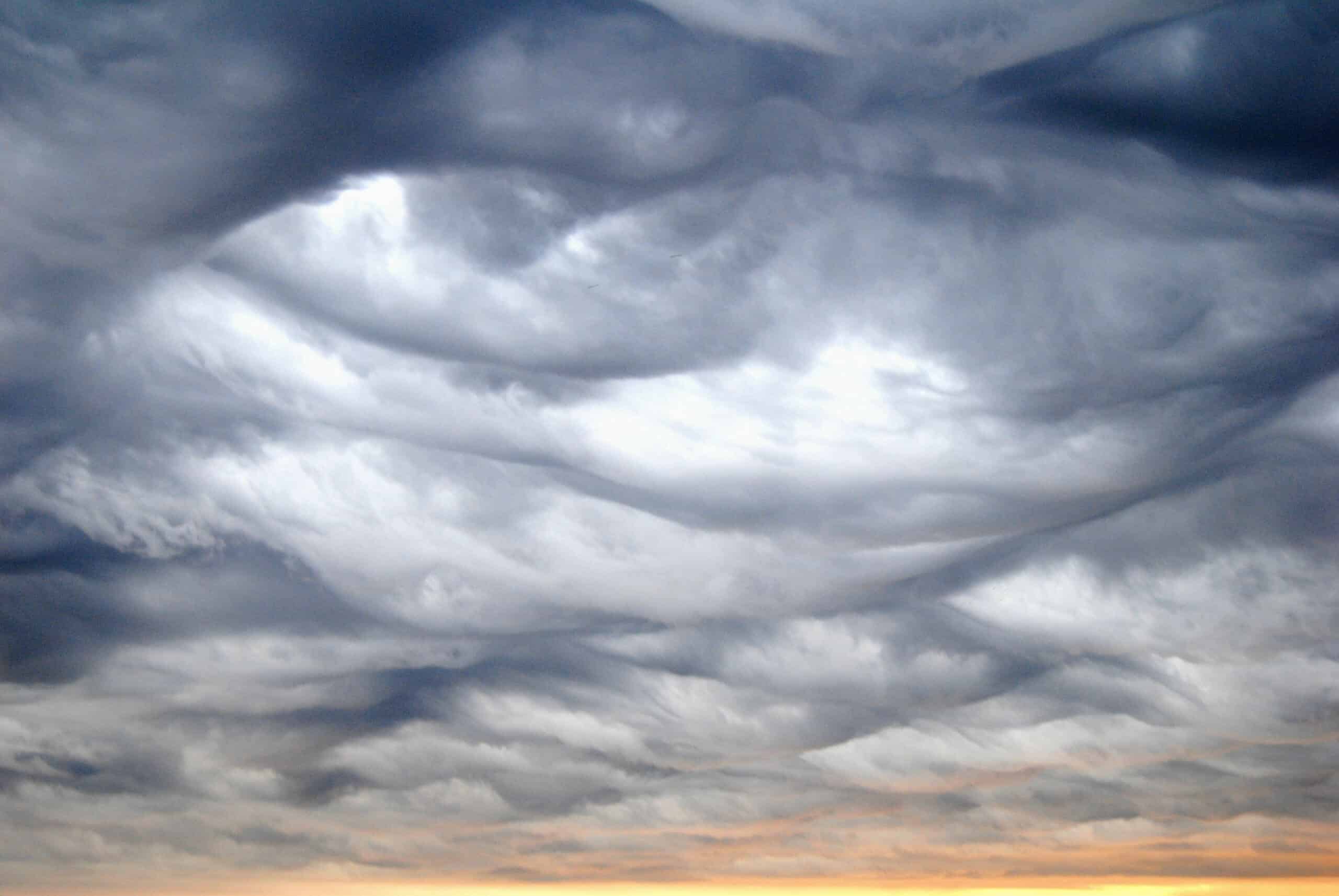
Nimbostratus clouds form through the deep lifting of moist air over a broad area, typically ahead of warm or occluded fronts.
As warm air rises over cooler air, it cools and condenses into thick, continuous layers that can extend through much of the troposphere.
These clouds are dense, dark grey, and capable of producing steady, prolonged precipitation.
Appearance and Structure
Nimbostratus clouds have a featureless, diffuse base and appear darker than other stratiform types due to their depth and water content. They often obscure the sun completely and may hide other cloud layers above.
Beneath the main layer, fragments of cloud known as pannus or scud frequently form as precipitation evaporates in the lower atmosphere.
In contrast, cumulonimbus clouds, the convective counterpart of nimbus, form through intense vertical development, producing heavy showers, lightning, hail, and occasionally tornadoes.
While both types are associated with precipitation, nimbostratus represents steady, widespread rain, and cumulonimbus represents showery, localised activity.
Meteorological Significance
Nimbostratus clouds signify frontal lifting and large-scale ascent rather than convection.
They mark the mature stage of many mid-latitude cyclones and often precede the arrival of a warm front.
Precipitation from nimbostratus can last for many hours, sometimes leading to snowfall or freezing rain in colder climates.
Their thickness and extensive coverage make them major contributors to atmospheric albedo, strongly influencing regional radiation balance.
Because they form in stable air, turbulence is usually weak, but persistent drizzle and reduced visibility are common.
Historical Context
Howard’s use of nimbus, Latin for “rainstorm” or “shower,” completed his set of cloud types. Later meteorologists refined the term, using it as a modifier rather than a standalone genus.
Thus, nimbostratus describes layered rain clouds, while cumulonimbus describes convective storm clouds.
This change reflected growing understanding of precipitation mechanisms and vertical structure within weather systems.

