

Contrails, the hidden clouds of modern flight
Contrails are one of those everyday phenomena that most of us notice and rarely think about. Across many skies they appear as pale lines, sometimes brief and delicate, sometimes persistent and spreading until they look almost indistinguishable from natural cirrus clouds. Yet these thin ribbons of ice are remarkably rich in science. They sit at the intersection of aeronautics, atmospheric physics, meteorology and climate science.
What contrails are, in plain terms
Massive contrails created by commercial passenger plane
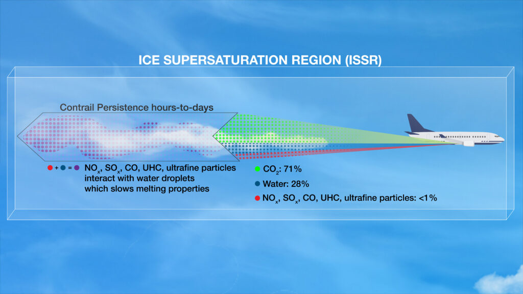
A contrail is a cloud composed of tiny ice crystals that forms in the wake of an aircraft flying in sufficiently cold and, in many cases, humid air. They form because the exhaust from jet engines is hot and moist: combustion of aviation fuel produces large amounts of water vapour as well as aerosol particles. When this warm, moisture-laden exhaust mixes with the cold ambient air at cruise altitudes, the extra water vapour can condense and then freeze, producing ice crystals that scatter sunlight and thus become visible as a white trail behind the aircraft. In other words, contrails are artificial clouds produced by the same basic process that forms natural cirrus clouds, but initiated by aircraft exhaust.
The physics of formation: mixing, saturation and the Schmidt-Appleman criterion
To understand contrail formation you must think about three things: the temperature of the ambient air, the humidity of that air relative to ice, and how the exhaust plume mixes with the surrounding air.
When hot exhaust mixes with ambient air it cools rapidly and mixes the water vapour with the surrounding atmosphere. Whether that mixed air becomes saturated enough for liquid droplets to form and then freeze depends on the ambient temperature and pressure, and on the amount of water vapour and small particles in the exhaust. The formal test scientists use to decide whether contrails will form is known as the Schmidt-Appleman criterion. In essence it asks whether the local cooling and mixing of exhaust and ambient air produce supersaturation with respect to liquid water or ice. If they do, tiny droplets form and freeze into ice crystals; a visible contrail appears.
The Schmidt-Appleman criterion can be expressed as a threshold condition relating ambient temperature, pressure and a factor that represents the plume’s properties (often called the contrail factor). The contrail factor encapsulates engine characteristics and the water yield from fuel combustion. Applied operationally, researchers use meteorological profiles of temperature and relative humidity together with representative contrail factors for different engines to compute whether contrails are thermodynamically permitted at a given altitude. Practical contrail forecasting tools implement this calculation and map the atmosphere for regions where contrails could form.
Several authors have refined and tested the Schmidt-Appleman approach because real atmospheres and real engine plumes are messy. Numerical weather analyses can underestimate upper-air humidity, and the microphysics of ice nucleation and particle growth complicate exact predictions. Nevertheless the criterion remains the central conceptual tool for contrail forecasts and for contrail-aware flight planning.
When and where contrails form
Most commercial airliners cruise between roughly 25,000 and 42,000 feet, where ambient air temperatures commonly fall below minus 30 or minus 40 degrees Celsius. Contrails are most likely when the air at those altitudes is cold and close to saturation with respect to ice. Ambient relative humidity with respect to ice is the crucial variable. If the air is too dry a contrail will not form or will evaporate very quickly; if the air is ice-supersaturated a contrail can persist and even grow.

Meteorological situations that favour persistent contrails include large-scale flow regimes with weak vertical mixing and pockets of high upper-tropospheric humidity. These conditions are not rare; observational and modelling studies show that substantial fractions of flight corridors, especially over the North Atlantic and parts of Europe and North America, are frequently conducive to persistent contrails. The frequency and spatial distribution of such favourable layers determine how often persistent contrails appear.
Types of contrails
Conventionally contrails are sorted into three pragmatic categories used by forecasters and educators:
- Short-lived contrails. These form in slightly moist air and may be visible for only seconds or a few minutes before vanishing as the ice crystals sublimate. They appear as thin, well-defined lines that fade quickly.
- Persistent non-spreading contrails. These persist for tens of minutes to a few hours but retain their narrow filamentary shape. They indicate that the ambient layer is sufficiently humid to sustain ice crystals, but atmospheric shear or turbulence is limited so the trail does not spread widely.
- Persistent spreading contrails, sometimes called contrail cirrus. These persist for hours and spread laterally under the action of wind shear and diffusion, often forming broader, thin sheet or web-like cloud structures that closely resemble natural cirrus. Such contrail cirrus can cover large swathes of sky and, from satellites, may be indistinguishable from naturally produced cirrus clouds.
These categories are empirically useful. They also map onto different climatic effects because the radiative impact of a narrow line differs from a broad, semi-uniform cirrus layer.
How long do contrails last and how far can they spread?
The lifetime of a contrail depends on the size and number of ice crystals initially produced, the ambient humidity and temperature, and atmospheric dynamics such as shear and turbulence. Observations show a wide range of lifetimes. Many contrails dissipate rapidly in dry air, but persistent contrails can last for hours. Satellite studies and airborne observations report contrail clusters that have been visible for up to around 14 hours in some cases, though typical lifetimes for persistent spreading contrails are often in the band of four to six hours. During that time a contrail can spread horizontally over tens to thousands of kilometres, depending on wind patterns and the initial amount of ice. There are documented cases where contrail coverage expanded to tens of thousands of square kilometres within a few hours under favourable conditions.
The spreading process is partly passive: as thin filaments of ice crystals are advected by winds that vary with height, differential advection stretches and shears the trail into ribbons, sheets and eventually broader cirrus decks. Diffusion and collision processes among crystals, coupled with local humidity, determine microphysical ageing and eventual dissipation. Studies that combine satellite remote sensing, in situ aircraft sampling and models have helped characterise these processes but considerable uncertainty remains in microphysical details.
Contrails and cirrus: why contrail cirrus is effectively the same as natural cirrus
As contrails age and spread they become morphologically and microphysically similar to natural cirrus clouds. The ice crystal sizes and optical thicknesses overlap with those of natural cirrus, and in many classification schemes contrail cirrus is simply a subset of cirrus because it occupies the same altitude range and shares the same composition and radiative behaviour. In radiative and climate studies, what matters is the cloudiness and optical properties rather than the origin of the ice crystals. Observational work therefore often treats contrail-induced cirrus as a component of the global cirrus population for the purpose of estimating radiative forcing.
Predicting contrails: practical formulas and operational forecasting
Operational contrail prediction relies on meteorological soundings or model analyses and on the Schmidt-Appleman framework. There are a number of related practical approaches:
- The Schmidt-Appleman criterion as a threshold test. In simplest terms, this criterion states that at a given pressure level and ambient temperature there is a critical temperature Tc below which contrails can form for a given contrail factor. Practitioners compute Tc from physical relationships that relate exhaust water yield, plume expansion and ambient thermodynamic properties. If the ambient temperature is colder than Tc, contrail formation is permitted. The contrail factor encapsulates the effective water content of the plume and depends on fuel properties and engine efficiency.
- Ice-saturation or persistence criteria. Even if the S-A test is met, a contrail will only persist if the surrounding air remains at or above ice saturation. Operational tools therefore compute the ambient relative humidity with respect to ice and compare it with thresholds that imply persistence. Some forecasting systems map regions where contrails can both form and persist, producing contrail risk maps.
- Numerical contrail modules within weather and climate models. Advanced models simulate plume microphysics and ice crystal evolution to project contrail formation and growth. Such simulations require good humidity fields; upper-air humidity is challenging to capture accurately in operational analyses, and therefore contrail forecasts carry inherent uncertainty. Recent research has focused on improving such models and validating them against satellite and aircraft observations.
For practical, hands-on forecasting there are open-source toolkits and calculators that implement the Schmidt-Appleman and persistence checks. These are useful for flight planning or for experiments to identify routes and altitudes that minimise contrail risk. One example is a contrail mapping package used by researchers which integrates meteorological reanalysis data to evaluate where the S-A condition is met.
Engine technology and contrail propensity: high bypass versus low bypass turbofans
Engine design and combustion properties matter. Two aspects of the propulsion system influence contrail formation:
- Water vapour production. Combustion of hydrocarbon fuel yields water vapour roughly proportional to the hydrogen content of the fuel. The mass of water produced per unit of fuel burned is therefore a property of fuel chemistry and the combustion process.
- Aerosol particle emissions. Exhaust particles act as ice nucleation sites and determine the number of ice crystals that form. Engines that emit many small soot particles produce many ice crystals; engines that emit fewer particles produce fewer but generally larger crystals. The initial number and size distribution of crystals influences the optical properties and lifetime of a contrail.
High bypass turbofan engines, which are used on modern airliners, have a large fan that moves a great deal of bypass air around the core. These engines are efficient and produce large mass flow but relatively cooler exhaust gas temperatures at the nozzle plume compared with older, low bypass engines for the same thrust. They also typically emit different particle number distributions compared with older engines. Low bypass engines, which were common on earlier jets and military fighters, tend to have different exhaust characteristics and may produce different contrail signatures. Empirical and model studies show that engine technology affects the contrail factor used in forecasts, and hence the maximum temperature at which contrails form. Operationally, contrail forecasts therefore use representative contrail factors for engine families rather than assuming all engines are identical.
The climate literature has discussed whether modern low-emission engines, alternative fuels or particle mitigation technologies might reduce contrail formation or alter contrail optical properties. The picture is complex. Reducing soot emissions tends to reduce the number of ice crystals, which can make contrails optically thinner for a given ice mass but can also change crystal growth behaviour in ways that affect lifetime. Consequently, some mitigation options could have counterintuitive effects on radiative forcing unless they are examined carefully with microphysical models and observations. The FAA and international research groups explicitly identify engine particle emissions and fuel composition as key uncertainties in contrail climate impact assessments.
Radiative effects and climate relevance
Why do scientists care about contrails? The simple reason is radiative forcing. Thin ice clouds at flight levels affect the Earth’s radiation balance in two competing ways. They reflect incoming shortwave solar radiation, which cools the surface during daytime. They also trap outgoing longwave infrared radiation emitted by the Earth, which warms the surface and lower atmosphere, especially at night. For contrails and contrail cirrus the net effect tends to be a small positive radiative forcing, that is net warming, because the longwave trapping often outweighs the shortwave reflection. Several studies, including satellite analyses and modelling work, have estimated that contrails and contrail-induced cirrus contribute a non-trivial portion of aviation’s total climate forcing, in some assessments comparable to or in excess of aviation carbon dioxide emissions on short to medium timescales.
This climatic sensitivity is also what makes contrails an actionable target for mitigation. Because contrail forcing depends on where and when flights occur, modest changes in routing or altitude can reduce contrail radiative forcing rapidly, potentially producing near-term climate benefits. Research projects and roadmaps from aviation agencies emphasise contrail avoidance via minor altitude adjustments and improved forecasting as promising near-term measures. However, widespread operational adoption requires accurate contrail forecasts, coordination with traffic management and careful evaluation of fuel burn and safety trade-offs.
A short history of contrail observation and research
Contrails are not new. The earliest published observations date from the years during and immediately after the First World War, when aircraft began to reach altitudes high enough for condensation trails to form. One early documented observer was Zeno Diemer, a German pilot who reached altitudes above 30,000 feet in 1919 and described condensation streamers. During the Second World War contrails were frequently observed during large air operations and dogfights, becoming a familiar feature of wartime skies. Photographs and newsreel footage from the 1940s show elaborate networks of trails from fighters and bombers. Researchers later used some of these wartime episodes as natural experiments to study how dense air traffic affected cloudiness and local temperatures.
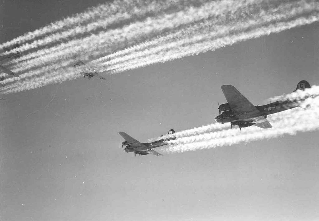
Bombers in W2 leaving Contrails
Post-war developments in engine technology and the advent of high-altitude jet transport in the 1950s turned contrails into an everyday phenomenon across heavily trafficked corridors. Scientific interest in contrails increased through the latter half of the twentieth century as atmospheric scientists recognised that aviation could produce persistent cloudiness and potential climatic effects. Key observational and theoretical work in the 1960s and 1970s established the basic microphysical processes and highlighted the possible climatic significance. Satellite remote sensing from the 1970s and 1980s onwards enabled regional and global studies of contrail coverage, while modern airborne campaigns and high-resolution models have deepened understanding in the last two decades.
A particularly striking historical episode used by researchers was a series of very large Allied bombing missions in 1944. The density of aircraft produced extensive contrail coverage over parts of Europe and provided a natural experiment showing measurable effects of aviation clouds on local surface temperatures. Researchers who have revisited these events with modern techniques have used them to illustrate how intensive air operations can lead to detectable changes in weather parameters.
Expanded historical timeline of contrails, with wartime primary sources
Below I extend the article with a focused, evidence-based historical timeline that emphasises primary sources and wartime archive material. I list key events in chronological order, describe what was recorded at the time, and point you to archival images, contemporary reports and modern analyses that use wartime observations as natural experiments. Where possible I give concrete dates and primary-source references so you can follow the trail yourself.
1919 — the first recorded high-altitude pilot observations
Event and significance
One of the earliest documented observations of long, thin condensation trails comes from Franz Zeno Diemer. On 17 June 1919 Diemer, a German test pilot, reached altitudes above 30 000 feet and recorded condensation features behind his aircraft. These early high-altitude flights showed that condensation trails were a feature of flight once aircraft routinely reached the cold upper troposphere. Contemporary accounts of Diemer’s altitude records are among the earliest reports that link high flight levels with condensation phenomena.
Where to see primary material
- Biographical and record summaries for Franz-Zeno Diemer appear in aviation histories and in primary record compilations; the Wikipedia entry for Diemer summarises his 1919 altitude flights and points to period sources for his achievements.
Late 1930s–1940 — aerial combat and photographic records from the Battle of Britain
Event and significance
By the late 1930s and into 1940, aerial engagements between fighters and bombers routinely produced visible contrails. Photographs and newsreel stills from the Battle of Britain show clear contrail patterns crisscrossing the sky on specific dates, for example 18 September 1940. These images are valuable primary sources because they document contrail frequency in an era when civil aviation at cruise altitudes was rare. Museum collections hold many such photographs.
Where to see primary material
- The Imperial War Museums collection includes dated photographs showing contrails during the Battle of Britain; catalogue entries provide context and metadata for each image.
- National and national-history museum collections, such as New Zealand History and other national archives, also host period photos and captions linking contrails to dogfights and large formations.
1943 — Operation Gomorrah and large daytime formations
Event and significance
The Allied bombing campaign that included Operation Gomorrah over Hamburg in July–August 1943 involved sustained sorties at altitude and produced extensive contrail coverage visible from the ground. Contemporary reports and later historical treatments of the raids document the scale of aircraft operations and the resulting sky conditions. These raids are important as early, high-density flight examples that caused persistent and widespread contrail patterns and helped motivate later scientific interest in aviation-induced cloudiness.
Where to see primary material
- Detailed histories of the Hamburg raids, including operational summaries and photographs, are held by museums and history organisations such as the National WWII Museum and in national archives; these provide operational flight counts, timings and eyewitness descriptions.
1943–1944 — very large USAAF daytime formations and natural experiments
Event and significance
Large daytime USAAF bomber formations in 1943 and 1944 created skies that witnesses described as white with contrails. One particular mission frequently analysed by researchers occurred on 11 May 1944, when some 1 444 bombers and fighters departed English airfields. Modern researchers have revisited archival weather records and eyewitness accounts for that day to study possible short-term weather effects of extensive contrail coverage. The rarity of civil high-altitude traffic at the time makes these raids a useful natural experiment: areas with heavy contrailing could be compared with quieter regions to test contrails’ influence on surface temperature and radiation. Recent studies using those archives have reported measurable screening effects on morning temperatures in affected areas.
Primary sources and analyses
- Contemporary mission logs and operational orders are held in national air force archives and in unit histories. These give flight timings and routes that researchers have used to reconstruct the aerial coverage.
- Modern analyses, for instance the Lancaster University / ResearchGate case study, explicitly reference wartime mission records and meteorological observations to quantify contrail-induced cloudiness.
Post-war decades — from anecdote to research programme
Event and significance
After 1945 scientists increasingly treated wartime observations as data. The immediate post-war years saw theoretical work on plume mixing and condensation physics, and the later decades brought satellite remote sensing that could map contrail occurrence globally. Researchers used wartime photographic and meteorological archives to validate early ideas and to show that contrail patterns could alter local radiation budgets. The 1960s and 1970s saw systematic interest in the climatic role of aircraft condensation trails, culminating in more formal programmes of contrail observation from the 1980s onwards.
Primary sources and typical archives
- National meteorological archives hold upper air soundings, synoptic charts and station logs from wartime and immediate post-war years. These are indispensable for reconstruction studies.
- Air force operational records, squadron diaries and photographic collections supply formation sizes, altitudes and timing that can be paired with meteorological data.
How modern researchers use wartime archives: methods and examples
Methodological approach
Researchers combine archive materials in three steps: first they reconstruct flight densities and timings from operational records; second they extract meteorological state from station logs and soundings; third they compare observed surface variables such as diurnal temperature ranges in regions under heavy contrailing and in control regions. The wartime records are particularly useful because commercial high-altitude traffic was limited, which reduces confounding from ordinary civil flights. The Lancaster and Birmingham research teams are examples of work that apply these methods.
Representative modern studies that exploit wartime data
- The Lancaster University paper “World War II contrails: a case study of aviation-induced cloudiness” collates wartime meteorological records with mission logs to quantify sky whitening during large raids. That paper and related outputs are a direct line from archive evidence to modern scientific inference.
Notable primary materials and where to access them
Below are concrete archival sources and collections that researchers and interested readers can consult. Many of these holdings are digitised or catalogued online with metadata; some require museum or archive visits for high-resolution copies.
- Imperial War Museums photographic collection
- Catalogue includes dated photographs of contrails from the Battle of Britain and other wartime dates. Use catalogue IDs and date filters to find images with metadata.
- National WWII Museum and allied national history archives
- Operational summaries and photographic records from major raids including Operation Gomorrah. These repositories supply mission narratives and often link to first-hand accounts.
- National and regional meteorological archives
- Upper air soundings, synoptic charts and station logs for the 1940s are held by national meteorological services and national archives. Researchers often request specific station logs for dates of large raids. (Modern studies cite these directly when reconstructing humidity and temperature profiles.)
- Photographic libraries and newsreel collections
- Hulton-Deutsch/Corbis collections and other photo libraries host wartime stills that show spreading contrails over cities. These images are primary visual evidence and often come with provenance notes.
- Academic reconstructions and datasets
- Papers such as the Lancaster University study and ResearchGate-hosted PDFs provide collated datasets and references to the original archive documents they used. These modern syntheses make it easier to follow exactly which primary records were consulted.
Example case study, in brief: the 11 May 1944 mission
What the archives show
On 11 May 1944 a very large USAAF mission took off and produced dense contrail coverage over parts of England and northern France. Archive mission logs show the number of aircraft and general routing. Contemporary weather station logs give temperature and humidity observations for the morning and afternoon. Later researchers used those logs and the mission metadata to compare surface temperature anomalies below busy skies and in neighbouring quieter areas. The comparison produced statistically significant differences in morning temperature, consistent with contrail clouds screening incoming sunlight.
Primary sources to consult
- Unit mission reports and the USAAF records for May 1944, available in national air force archives.
- Surface station logs and upper-air soundings for southern England and northern France on 11 May 1944, held in national meteorological archives or their digitised collections.
- Modern reanalysis and the research reports by Birmingham and Lancaster teams that document the reconstruction steps and findings.
Limitations and cautions when using wartime archives
- Metadata gaps
- Not all wartime records are complete. Some mission logs lack precise altitude fields or exact timing, and many meteorological stations had sparse sensor coverage compared with modern standards. Treat gaps with caution.
- Changing instrumentation and measurement practices
- Instrument accuracy and observational practices differ between the 1940s and today. For example, humidity measurements at cold upper-air temperatures were more error prone. Modern reanalysis helps, but direct comparison requires careful error analysis.
- Confounding wartime factors
- Large raids also produced aerosols and smoke from fires, which can confound purely contrail-based radiative interpretations. Studies explicitly attempt to separate contrail effects from smoke and fire effects where possible.
Interesting phenomena and operational implications
Several curious and practically important phenomena arise around contrails:
- Contrails sometimes form a short stub behind the aircraft and then disappear before reappearing tens or hundreds of metres further back. That gap arises because the exhaust plume takes a short distance to mix with ambient air and cool enough to reach saturation. The gap length contains useful information about plume dynamics.
- Military research has considered contrail suppression for stealth and operational security. During the Cold War and later, methods were examined to reduce contrail visibility by modifying exhaust chemistry or flight profiles. These efforts underscore that contrails are not merely decorative: they can reveal aircraft position at long ranges.
- Contrail forecasting is now an operational research topic for air traffic management. The idea of contrail-aware routing is to choose flight levels or timings that reduce contrail formation for the same overall safety and fuel constraints. Pilot projects and simulations indicate substantial potential reductions in contrail radiative forcing with small altitude changes, but scaling these measures requires robust prediction systems and coordination across airlines and air traffic control.
What we still do not know, and where research is heading
Contrail science has matured, but significant uncertainties remain:
- Upper-tropospheric humidity is difficult to observe and model. Contrail prediction is highly sensitive to humidity, so biases in humidity fields lead to forecasting errors. Improving humidity measurements and reanalyses is a key research need.
- The microphysics of freshly emitted exhaust plumes is complex. How aerosol particle emissions from different engines and fuels translate into initial ice crystal populations, and how that affects contrail optical properties and lifetime, is an active research area. This topic is central to assessing whether emissions reductions will reduce contrail climate impacts.
- The net climate effect of contrails depends on temporal and spatial patterns of flights as well as day-night differences. While many studies find a net warming effect, local and temporal variability means mitigation strategies must be assessed carefully. Large-scale experiments and improved satellite records are helping to constrain the net forcing more precisely.
Practical advice for observers and citizen scientists
If you enjoy watching the sky, you can contribute to understanding contrails in simple ways. Note the type of contrail you see, the time of day, windiness and cloud situation, and take photographs with time stamps and compass bearings. Participatory science initiatives and cloud observation protocols accept such observations and can help place local sightings in a larger meteorological context. Satellite imagery and contrail forecast maps are also publicly available and useful to compare against ground observations.
Why contrails matter
Contrails are a striking example of how a routine human activity produces rapidly evolving atmospheric structures that matter for climate and weather. They are clouds created by the same physical processes that sculpt natural cirrus, but they differ in origin and timing, and their radiative effects are concentrated in the densely travelled airways used by modern aviation. Because contrail forcing is sensitive to flight timing and altitude it is also a tractable target for mitigation, provided we can accurately forecast where contrails will form. The scientific challenge blends detailed microphysics with operational meteorology and air traffic logistics. As aviation evolves with new engines, fuels and operational concepts, contrail science will remain central to assessing and reducing aviation’s short to medium term influence on climate.

